An unusual way of mapping Earth’s gravity suggests that a “gravity hole” beneath Antarctica is even deeper than the gravity hole beneath the Indian Ocean, which scientists have long considered the deepest. The strength of Earth’s gravity at its surface varies across different regions, and a gravity hole marks a place where it is weaker than average.
“The Indian Ocean feature remains a major geoid low, but it is no longer the deepest.”
Petar Glišović, a geophysicist at the Institut de Physique du Globe de Paris in France, explained that the idea of the Indian Ocean Geoid Low (IOGL) being Earth’s deepest gravity hole isn’t necessarily “wrong”; it’s just the result of interpreting data with a different lens. “What changes in our study is the reference frame used to interpret the gravity field,” Glišović said. “The Indian Ocean feature remains a major geoid low, but it is no longer the deepest.”
Glišović is the lead author of a new study published in Scientific Reports that uses this unconventional reference frame to study the evolution of the Antarctic Geoid Low (AGL).
A New Mapping Method
The researchers used new data to reconstruct the rough “geoid,” an irregular shape depicting the varying strengths of gravity at Earth’s surface. The geoid has been extensively measured for decades, both by measurements at the surface and by satellites in orbit, and it suggests the structure of the mantle underneath.
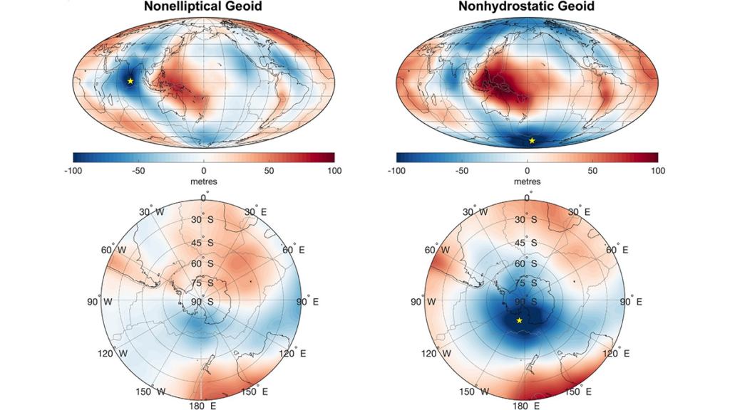
Scientists usually construct Earth’s gravity map by comparing the geoid to a “reference ellipsoid” that compensates for the way our planet bulges near the equator. It’s a standard used by many experts who study Earth’s gravity and in satellite engineering, where discrepancies in Earth’s gravity need to be taken into account because they cause wobbles in an orbit.
By this measure, the IOGL is the deepest gravity hole on Earth, causing sea levels to be more than 100 meters below normal at this location. (Counterintuitively, regions of weak gravity cause depressions in the ocean: With less gravitational force pulling water to the area, water flows away to regions of higher gravity.)
The standard geoid is nonelliptical and accounts for Earth’s shape, including the bulge at its equator created by its rotation and the mantle underneath. The unconventional geoid in the latest study, however, is based on an ideal “hydrostatic ellipsoid” in which fluids are at rest. By subtracting this hydrostatic ellipsoid from the gravity data, the researchers created a “nonhydrostatic” geoid that accounts for deviations between observations and these ideal conditions. This method allowed the researchers to study the mantle structure near the AGL, which appears almost insignificant in the usual model. The data were based in part on the latest measurements from the GRACE (Gravity Recovery and Climate Experiment) satellites—and by this measure the AGL, beneath the west of Antarctica near the Ross Sea, is markedly deeper than the IOGL.
Tracing a History
Glišović and his coauthor, University of Florida geophysicist Alessandro Forte, determined that the AGL has existed for at least 70 million years and that it moved from beneath the South Atlantic Ocean to its present location between 50 million and 30 million years ago, when a rapid redistribution of Earth’s mantle mass caused the planet’s axis of rotation to shift.
In particular, the changes in the mantle seem to have involved the interplay of the sinking of tectonic slabs beneath Antarctica and buoyant upwellings of rock from the boundary of Earth’s mantle and its core, “much like the circulation in a lava lamp, but on a timescale of tens of millions of years,” Glišović said.
Importantly, the changes in the gravity hole beneath Antarctica over the past 77 million years may have encouraged the growth of that continent’s ice sheets. Glišović stressed that it’s only a hypothesis but that the permanent glaciation of Antarctica happened about 34 million years ago, which coincided with the structural changes of the AGL.
“Even if you remove the effects of Earth’s ellipticity, you still get a geoid low in Antarctica.”
The authors speculated that lower sea levels around Antarctica from the deepening AGL may have created conditions that caused the continent’s ice sheets to form and then grow.
“We think the timing is compelling enough to take seriously,” Glišović said. “The two events overlap in time.”
Geophysicist Attreyee Ghosh of the Indian Institute of Science in Bangalore was not involved in the latest study but has researched the evolution of the IOGL.
She explained that the new study is referencing Earth’s geoid to a “nonhydrostatic” ideal as a way to highlight the evolution of the AGL, which is often overlooked in studies that consider only the more common “reference ellipsoid.”
But she emphasized that this unconventional frame of reference does not alter the strength of Earth’s gravity at either location.
“The main point of the paper…is that even if you remove the effects of Earth’s ellipticity, you still get a geoid low in Antarctica,” she said. “And that has to do with mantle dynamics, and that’s what they’re trying to explain.”
—Tom Metcalfe (@HHAspasia), Science Writer
Citation: Metcalfe, T. (2026), Scientists remap Earth’s gravity, Eos, 107, https://doi.org/10.1029/2026EO260096. Published on 26 March 2026.
Text © 2026. The authors. CC BY-NC-ND 3.0
Except where otherwise noted, images are subject to copyright. Any reuse without express permission from the copyright owner is prohibited.