
If you commute Victor to Jackson, haul freight through Togwotee, or planned a late-season ski trip to Grand Targhee this weekend, the next 48 hours are the problem. Everyone else has less to worry about than the warning text suggests. The National Weather Service in Riverton issued its Winter Storm Warning on April 15 for the Absaroka Mountains, the Teton and Gros Ventre Mountains and Yellowstone National Park, in effect from 6 PM Wednesday to 6 AM MDT Friday. NWS Billings has a parallel warning on Montana’s Absaroka/Beartooth and Crazy Mountains from noon Wednesday through the same Friday cutoff. Snow totals above 8,000 feet could reach 20 inches across the Wyoming ranges, with 12 to 24 inches above 9,000 feet in the Absaroka/Beartooth. Gusts hit 30 to 50 mph, ridges touch 55.
Three corridors matter: US-26/287 over Togwotee Pass, WY-22 over Teton Pass, and I-90 through western Montana. Chain law level 1 is close to guaranteed on the Wyoming passes by Wednesday night. Whether WYDOT escalates to level 2 depends on how hard the wind hits Thursday afternoon, and that call often comes with less than an hour’s notice.
The Storm
the Northern Rockies. It is the same system currently burying the Oregon and Washington Cascades under a Winter Storm Warning of their own, with NWS Portland forecasting up to 22 inches above 2,500 feet through Thursday morning. By Wednesday evening the system reaches Wyoming and Montana, and it slows as it climbs the spine of the Rockies. Snow keeps falling for roughly 36 hours.
Snow levels stay above 6,500 feet through most of the event, so valley floors in Jackson, Dubois, Cody and Bozeman mostly see rain or light wet snow. The damage is concentrated at pass level, between 7,500 and 10,000 feet, where ridge-top winds push snow horizontally across exposed highway segments. The heaviest period runs from late Wednesday night through Thursday afternoon.
Zone Forecasts
The headline numbers come from two NWS offices. NWS Riverton has 9 to 18 inches across the Absaroka, Teton/Gros Ventre and Yellowstone zones with up to 20 inches at the highest elevations, gusts 30 to 50 mph, and travel impacts specifically called out for Teton Pass and Togwotee Pass. NWS Billings is the heavier side: 12 to 24 inches in the Absaroka/Beartooth with the heaviest totals above 9,000 feet, the same range in the Crazy Mountains, and an explicit note about increased avalanche danger on both.
I-90 sits outside the Warning zone but not outside the storm. NWS Missoula has a Winter Weather Advisory covering the interstate from Lookout Pass to Haugan with 6 to 12 inches forecast, and a separate advisory on Bozeman Pass with 2 to 6. Winter Storm Watches extend across the Gallatin and Madison County Mountains with 10 to 15 inches in higher terrain.
NWS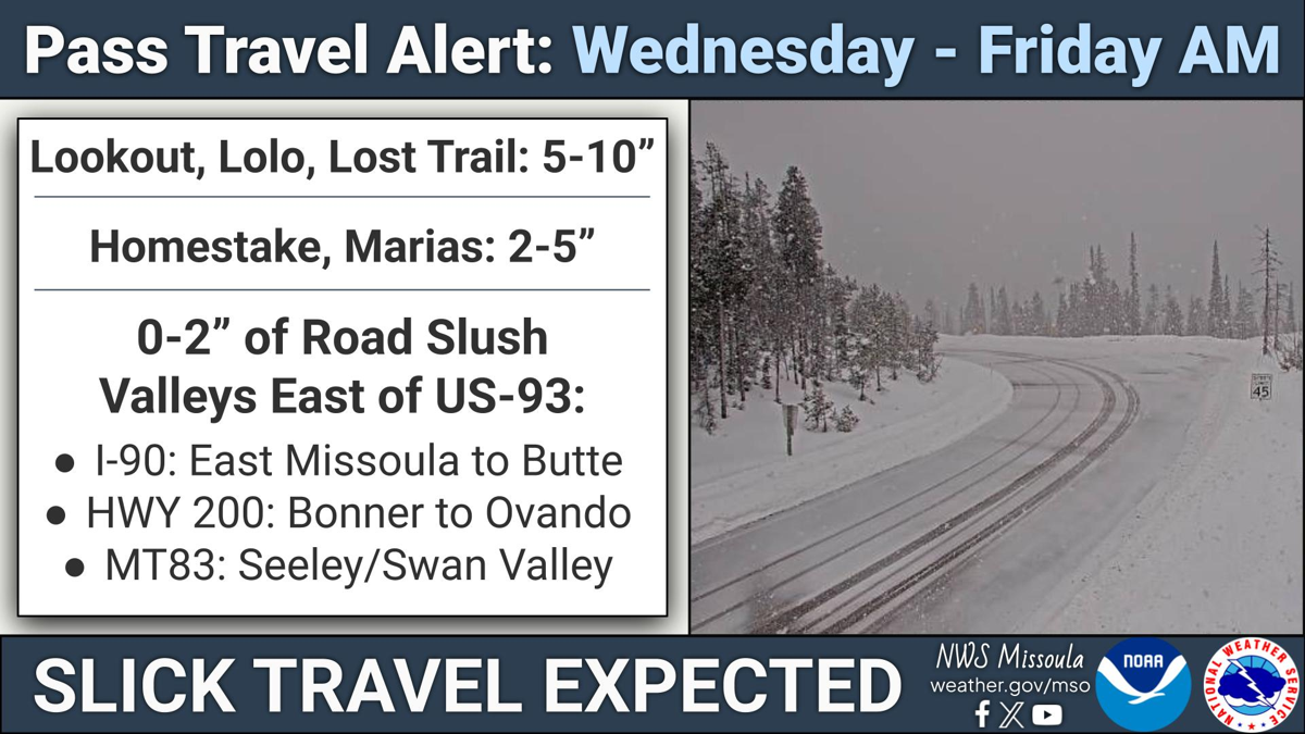
The Highways
US-26 and US-287 over Togwotee Pass (9,655 feet). The primary link between Dubois and the Jackson Hole valley, and the most direct route to Grand Teton National Park from eastern Wyoming. With 9 to 18 inches forecast at pass elevation and ridge winds to 55 mph, chain law level 1 should be considered a baseline. Togwotee has a long history of multi-day closures during blizzards. Expect chain requirements Wednesday night with possible closure Thursday. Check status at wyoroad.info.
WY-22 over Teton Pass (8,431 feet). Some of the steepest grades of any highway in the continental US, between Wilson and the Idaho state line. The pass reopened on its permanent rebuilt alignment in late June 2025 after the June 2024 Big Fill landslide, and WYDOT has remained aggressive about closures during heavy snow events. The permanent road used lightweight foamed-glass aggregate fill designed to reduce the risk of recurrence, but the pass’s steep grades and heavy storm exposure mean it shuts down readily when visibility drops. Expect chain law level 1 starting Wednesday evening and treat the pass as high risk through Friday morning.
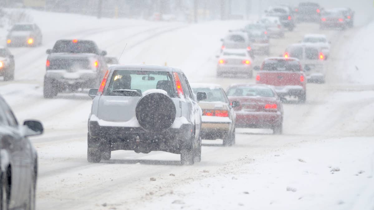
I-90 through western Montana, including Lookout Pass and Bozeman Pass. The interstate itself is not under a Winter Storm Warning, but advisories are in effect for the Lookout Pass segment (6 to 12 inches forecast) and for the Bozeman Pass area (2 to 6 inches). I-90 has a history of closures between Bozeman and Park City during mountain storms of this intensity, and MDT will likely impose chain requirements and single-lane operations in the worst stretches on Thursday. Live conditions at 511mt.net.
I-90 and US-191 approaches to the Absaroka/Beartooth. Routes climbing south from I-90 into the warning zone, including access toward Red Lodge, Cooke City and the north entrance of Yellowstone, run straight into the heaviest accumulation area. Expect significant slowdowns and potential short closures on mountain approach segments.
US-212 Beartooth Highway (10,947 feet). Seasonally closed and not a travel option this week. NWS Billings forecasts up to 24 inches of fresh snow at those elevations, which would make it impassable regardless of classification.
When to Drive
Wednesday afternoon is the last clean window — snow levels are still above pass level through late afternoon, and anyone with business on the far side should move now. The storm hits at pass elevations Wednesday evening, and chain law level 1 likely starts on both Wyoming passes by late that night. Thursday is the worst of it: wind gusts peak on exposed ridges, visibility drops toward zero in bursts, and this is when WYDOT closures are most likely on WY-22 and US-26/287. MDT may close I-90 segments between Bozeman and Livingston during the Thursday afternoon peak. Snow eases Thursday night into Friday morning as the system pulls east, but lingering chain requirements and single-lane operations are likely through sunrise. Both warnings expire at 6 AM MDT Friday.
Why This Storm Lands Harder Than the Numbers Suggest
A 24-inch spring dump across the Northern Rockies is not itself unusual. What makes this one different is the timing, and the timing is the story.
Montana snowpack hit record-low levels across a third of long-standing monitoring sites this month, with some lower-elevation stations completely melted out by April 1. Bridger Bowl closed three weeks ahead of schedule after a mid-March warm spell. Livingston is running its warmest year-to-date since records began in 1948. That is the context this storm drops into: dry soil, early-melting snowpack, a ski season already closed out in several places. 24 inches of fresh snow above 9,000 feet will not reverse that pattern — it reshuffles where the problems land, not whether there are problems. Avalanche risk climbs sharply in terrain that had settled into late-season conditions, and snow dropping onto saturated soil at lower elevations after Friday’s warm-up is the kind of combination that produced the Teton Pass Big Fill landslide in June 2024.
The second thing worth flagging is the parallel event in the Pacific Northwest. The same Gulf of Alaska trough feeding 10 to 22 inches onto the Oregon and Washington Cascades is what drives this storm. Both regions are under simultaneous Winter Storm Warnings, which is not coincidence — it is the same continental-scale moisture plume clipping both mountain systems.