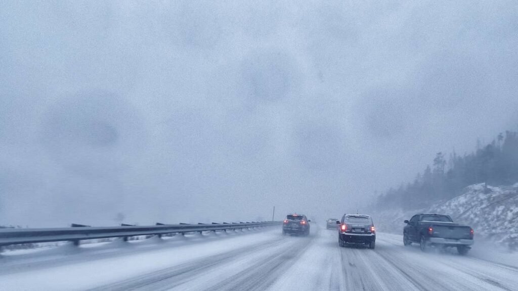
A late-season Pacific storm is hammering the Western United States this weekend with a one-two punch: a few feet of snow piling up in the northern Rockies, and damaging wind gusts shutting down major highways from the California coast through the Mojave.
Active National Weather Service alerts span nine states from Washington to Arizona. The NOAA Weather Prediction Center puts the chance of formal Winter Storm Warning criteria being met above 80 percent for parts of the Mountain West, and local NWS offices are expected to issue full warnings within hours.
The Numbers That Matter
Up to 20 inches of snow are forecast for the highest elevations of the Teton Range in Wyoming through Sunday night, per NWS Riverton. Wind gusts up to 70 mph are expected in the Eastern Sierra and Owens Valley in California from Sunday into Monday. Gusts to 60 mph are forecast on I-5 at Tejon Pass overnight Saturday into Sunday, per NWS LA/Oxnard. In total, nine Western states are under active snow or wind alerts from this single system: California, Nevada, Arizona, Idaho, Utah, Wyoming, Colorado, Montana, and Washington.
Roads You Should Think Twice About
Tonight and Sunday (the wind story):
- I-5 over Tejon Pass (the Grapevine) carries a High Wind Warning with 60 mph gusts overnight. This stretch is a chronic high-profile rollover zone even in normal conditions.
- US 395 through Owens Valley and Bishop is under the strongest active wind warning in the country right now, with gusts to 70 mph.
- I-10 at San Gorgonio Pass east of LA: 65 mph gusts forecast Sunday.
- I-15 across the Mojave between LA and Las Vegas: gusts of 55 to 60 mph Sunday.
- Lake Havasu, Bullhead City, Hoover Dam area (AZ/NV/CA tri-state): High Wind Warning Sunday into Monday with 60 mph gusts.
If you drive a tall vehicle (RV, box truck, anything with a roof rack), these are not the roads to push your luck this weekend.
Sunday night through Tuesday (the snow story expanding):
- I-70 across the Colorado Rockies (Vail Pass, Eisenhower Tunnel) is squarely in the path of the heaviest snow. Chain laws and full closures are likely.
- I-80 across southern Wyoming is also exposed and routinely closes for spring storms.
- Canyon roads above Salt Lake City (Big Cottonwood, Little Cottonwood, Parley’s) should be assumed to close.
What’s Already Happening
This is not a forecast for next week: it is already underway. Snow showers are active right now in the Washington Cascades and Olympics, with NWS Seattle calling for 4 to 8 inches above 4,000 feet through Sunday morning. That covers Snoqualmie Pass on I-90, Stevens Pass on US 2, and White Pass on US 12. Glacier National Park and Montana’s Rocky Mountain Front are under an NWS Great Falls advisory. Yellowstone, Grand Teton, and the Tetons are getting hammered already, with up to 20 inches forecast at the highest elevations of the Teton Range. The High Wind Warnings on I-5, in the Antelope Valley, and across the Mojave were all issued late Friday and overnight Saturday by NWS LA/Oxnard and NWS Las Vegas.
Getty Images
Why the Winter Storm Warning Is Imminent
The WPC Winter Storm Outlook is what NWS offices watch as a heads-up that a formal Winter Storm Warning is coming. The highest category on its probability scale is purple, meaning a greater than 80 percent chance of warning criteria being met, and there are already two purple footprints on the map: one over western Montana and northwestern Wyoming for Sunday, and a much larger one over western Colorado and northern Utah for Monday into Tuesday. WPC’s forecaster discussion states plainly that the trough “will bring a round of late season snow for the higher elevations of Colorado and Wyoming.” Formal warnings from NWS Salt Lake City, Grand Junction, Boulder, and Riverton will arrive in a matter of hours.
Driver Tips for the Weekend
- If you drive a tall vehicle (RV, box truck, anything with a roof rack), reconsider I-5 over Tejon Pass, I-10 at San Gorgonio, and I-15 across the Mojave through Sunday. High-profile rollovers are the single most common wind-related crash type on these roads.
- Carry chains if you’re crossing any Cascade or Rocky Mountain pass. Late-season storms catch most drivers in summer tires.
- Check your tire pressure before any mountain crossing. Pressure drops about 1 PSI for every 10°F of temperature drop, and a tire that left Denver at 70°F can sit 4 to 6 PSI low at 11,000 feet.
- Never use cruise control on snow, slush, or ice. Triple your normal following distance.
- Check live pass conditions before you leave. Caltrans QuickMap covers California; Colorado, Wyoming, and Washington each have their own state DOT live map at their respective .gov sites.
The Silver Lining
The storm clears the West by Wednesday May 20, leaving the long Memorial Day weekend (May 23-25) mostly clear for high-country travel. Late-season ski areas (Arapahoe Basin, Loveland, Snowbird) get a major fresh powder dump just in time.
This article will be updated as conditions evolve and as local NWS offices issue formal Winter Storm Warnings.