To make room for more housing without losing green space, planners in a new Toronto neighborhood flipped the usual approach: Instead of carving out room for parks and plazas, they made the streets do that work instead.
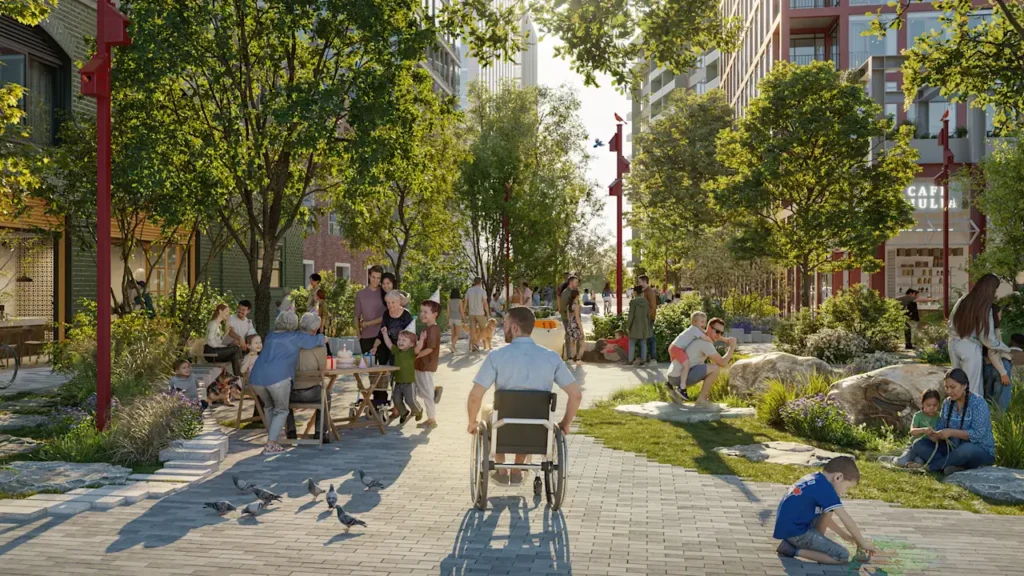
“The street is almost like a public courtyard,” says Rasmus Astrup, design principal and senior partner at SLA, the Denmark-based firm that was part of the design team for the new neighborhood, called Ookwemin Minising.
The main street will be car-free, “like a linear park,” he says, and filled with 400 trees. Other streets will allow cars, but prioritize large swaths of green space. The design gives residents public space, and doubles as climate infrastructure that can reduce urban heat, support biodiversity, and capture water in storms.
Rethinking development
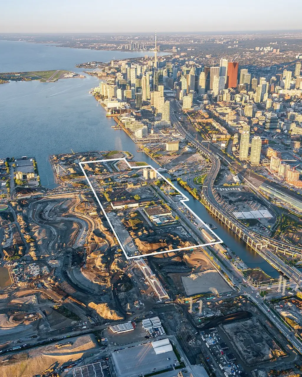
The area, south of downtown Toronto where the Don River meets Lake Ontario, used to be industrial. More than a century ago, the city channelized part of the river and filled in wetlands to make room for factories. The old infrastructure didn’t work well: The river and industrial zone became polluted and the changes to the river led to more flooding. But over a massive, decades-long redevelopment project, the local government cleaned up the waterfront, reshaped the river into a more natural shape, and added other new green space for flood protection. The larger project created an island where the new neighborhood will sit.
The original plan for the neighborhood, released two years ago, called for more typical North American streets—wide and built for cars, lined with blocks of uniform apartment buildings. After negative community feedback, the public development agency running the project, Waterfront Toronto, realized that the neighborhood needed more apartments to help deal with Toronto’s housing shortage. It brought in a new design team, including SLA, and asked them to come up with a new plan that would increase density by 27%.
“We thought, how are we going to do that? We don’t have the space,” says Astrup. They had to get creative with their approach and conceived of streets that perform like urban spaces. “The street is where you hang out, and where you read a book, and where you sit,” he adds.
The design takes out street parking, making room for plantings and seating areas. It’s filled with trees—not just in straight lines at the curb, like typical street trees, but extending deeper into the road, so cars have to take a meandering route and slow down. On the side of one street, the “Sandbar Trail” follows the path of a former sandbar and is filled with plants. Trees will also be planted in a natural mix of species. Filling the space with nature makes it a place where people want to be. “It doesn’t work if it’s asphalt and concrete,” Astrup says.
Directing the flow
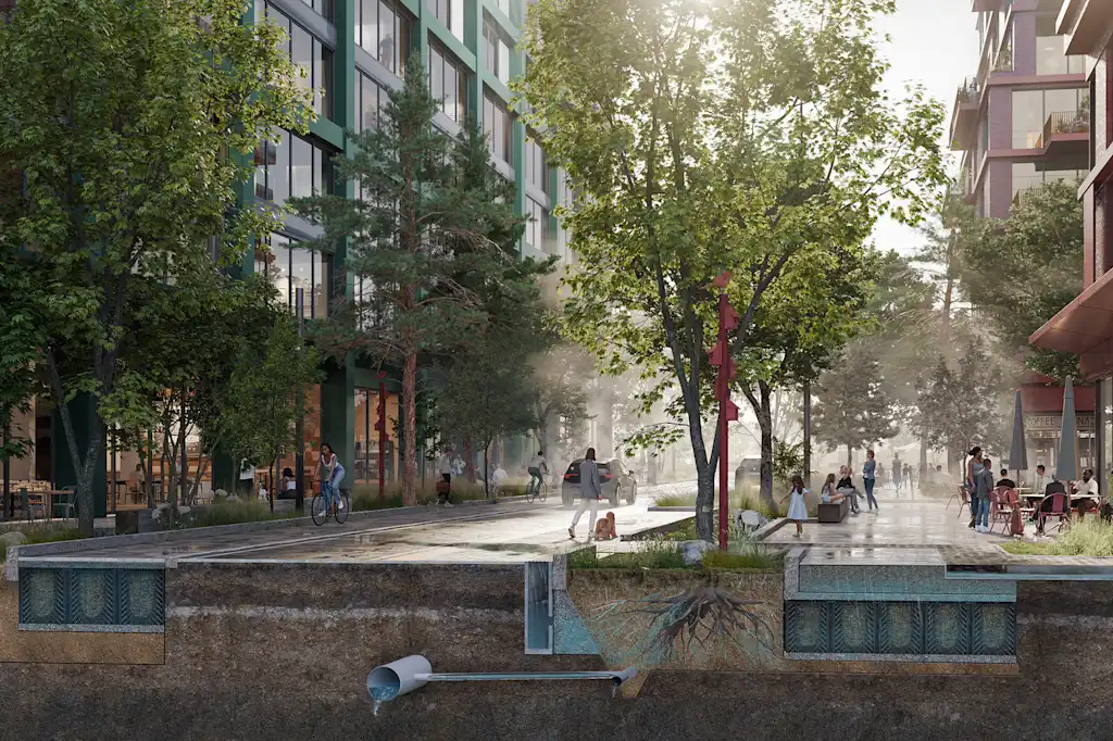
In a storm, the streets will suck up rainwater before it flows through traditional sewers. A “sponge” approach to street design, using green infrastructure, isn’t new. But it’s more often applied piecemeal to existing streets. Since the new neighborhood is built from scratch, planners could approach it differently.
First, since the island isn’t entirely flat, the team looked at how the existing topography directs the flow of water. The designers wanted to get away from a traditional street grid. “It’s a very rational and highly engineered system that has nothing to do with the natural flows in nature, and it’s actually fragile,” says Astrup.
The streets gently slope to guide water toward bioswales, or plant-filled channels designed to absorb rainwater. The streets also have traditional sewers, but nature captures and stores water first. “What this really does is provide resilience and reassurance,” says Jason Haelzle, market lead for property and buildings at GHD, an engineering firm that partnered on the design.
The plants and soil type inside each bioswale are chosen both based on the stormwater needs at that location and other goals like biodiversity. Other partners on the project, Trophic Design and Monumental, considered indigenous design priorities like “co-living” with other species; a network of greenery throughout the neighborhood will help wildlife move through the space.
Other cities could copy the nature-led approach, Astrup says. “I think we need to redefine what development means,” he says.