Most of the country is forecast to stay warm into fall, but six states can still see their first measurable snow in September. This year, the odds tilt higher across parts of Montana, Idaho and Washington, putting high-elevation roads and mountain passes back in play weeks before most drivers are thinking about winter.
That kind of early-season flip can happen fast. Denver went from 101 degrees to measurable snow in just three days in September 2020, a reminder that summer temperatures do not guarantee summer road conditions once a strong cold front reaches the Rockies.
Where September Snow Is Normal
The threshold that matters is 0.1 inches of accumulation, which is what the National Weather Service counts as measurable. Below that it is a dusting and it does not enter the record.
By that standard the six are western Montana, western Wyoming, the Colorado high country, Idaho, the Washington Cascades and Alaska, where National Weather Service 30-year data puts the first snow of the season in September during a typical year, and the same holds for the Bitterroots.
Northern Alaska is the only US region the Almanac’s predictions flag for early snow this fall. Duluth, Minnesota, carries a September snowfall normal of 0.1 inches, which puts northern Minnesota in the same statistical bracket even though its last genuine September snow was 2012. Everywhere else in the Lower 48, September snow is a tail event rather than a norm.
South and east of the Rockies the drop-off is sharp, with Dodge City, Kansas, not averaging its first measurable snow until November 19 despite a September 21 outlier in its file. The records make the distinction clear. Alamosa, Colorado, averages its first measurable snow on November 1 and has an earliest on record of September 8, 2020, when 6.7 inches fell.
Denver, with snowfall records running back to 1882, logged its second earliest measurable snow ever during that same September 2020 pattern.
What The Forecast Changes
The Almanac’s fall picture runs warm over the interior and cooler along the East and Pacific coasts, with rainfall below average almost everywhere. The West Coast, the central and northern Rockies and parts of Texas are the exceptions.
Two lines raise the snow odds. The Pacific Northwest is called cooler and wetter, with September possibly bringing three inches of rain above normal, and the northern Intermountain region runs cool with precipitation slightly above average.
One line lowers them. The High Plains, covering eastern Colorado and eastern Wyoming, is warmer and drier through both months. The Upper Midwest sits between the two, which keeps northern Minnesota and northern Wisconsin in play without making them likely.
Northern Alaska is the only US region the outlook names for snow. The other two references are Canadian, the Yukon and the Northwest Territories, and they matter here only because the Alaska Highway runs through the Yukon.
What It Looks Like When It Happens
Late September 2019 is the reference case. A cold airmass dropped into the northern Rockies and the Weather Prediction Center had Winter Storm Warnings posted across parts of northeast Washington, northern Idaho and central and western Montana, with High Wind Warnings alongside them. Browning, Montana, took 23 inches, and NOAA’s gridded snowfall analysis maps that footprint across the same states this year’s forecast is leaning on.
NOAA/NWS National Operational Hydrologic Remote Sensing Center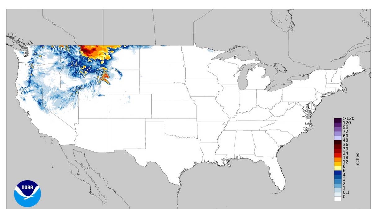
The Roads That Shut First
High elevation seasonal routes close on snow rather than on a calendar date, which is the part that catches out anyone planning a trip around published closing dates. They go before anything else. The Beartooth Highway on US-212 between Red Lodge and Cooke City runs above 10,000 feet and shuts for the season in October in a normal year.
Going-to-the-Sun Road through Glacier National Park operates on the same principle. Trail Ridge Road in Rocky Mountain National Park tops out above 12,000 feet and has closed temporarily on September snow more than once.
Interstate corridors behave differently. I-90 over Bozeman Pass, I-80 over Donner Summit and I-70 over Vail Pass stay open through early season events, but they are where chain controls and wet snow collisions concentrate when a system arrives before anyone has changed tires.
Teton Pass on WY-22 and Togwotee Pass on US-26/287 sit between the two categories, technically open during the first storms of the season but subject to short notice restrictions when wind starts loading the snow.
Tire Timing
The number worth knowing is 45 degrees Fahrenheit. Below it, the compound in a standard all-season tire begins to stiffen and shed grip, and the loss is progressive rather than sudden. Overnight lows in the northern Rockies cross that threshold well before the first snow does, which is why an early season storm tends to find most vehicles already running tires outside their useful temperature range.
A set of all-seasons that felt fine on the drive out can be a different tire on the drive back.
Tread depth is the second variable. The 2/32 inch legal minimum is a wear limit rather than a snow performance figure, and traction on packed snow drops off sharply below roughly 4/32.
Cold also pulls tire pressure down by about 1 PSI for every 10 degree fall in temperature, and a September front in Montana can move 40 degrees inside a day.
All wheel drive does not compensate for any of it, since it affects how a vehicle accelerates rather than how it stops or turns. What follows an early storm is refrozen slush on bridge decks and shaded curves, which is a braking problem.
How Much The Forecast Is Worth
The Old Farmer’s Almanac derives its long range predictions from solar science, climatology and meteorology, measured against the 1991 to 2020 statistical average prepared by government meteorological agencies. The publication puts its own accuracy at about 80 percent. Independent reviews by meteorologists and academic studies have generally landed closer to 50 percent.
The two almanacs also get conflated constantly. The Old Farmer’s Almanac, published since 1792, issued the fall outlook described here.
The Farmers’ Almanac, founded in 1818, is a separate publication with its own formula, and its winter 2026 to 2027 forecast is a different document released this month. Neither substitutes for a National Weather Service forecast inside a 72 hour window, which is the range at which an early snow stops being a seasonal probability and becomes a route decision.