KERR COUNTY, Texas (KXAN) — State and local officials are calling out federal forecasters amid deadly flooding in the Texas Hill Country over the extended Fourth of July weekend. The criticism comes, as funding cuts and staff shortages plague the National Weather Service and other emergency management agencies nationwide.
Texas Division of Emergency Management Chief Nim Kidd told reporters Friday original forecasts from the National Weather Service predicted 4 to 8 inches of rain in that area, “but the amount of rain that fell in this specific location was never in any of those forecasts.”
“Listen, everybody got the forecast from the National Weather Service, right?” Kidd said. “You all got it, you’re all in media, you got that forecast. It did not predict the amount of rain that we saw.”
Kidd added TDEM “worked with our own meteorologist to finetune that weather statement” but did not elaborate on any updated interpretation that would have led to more urgent warnings for evacuations.
The area actually received a much more significant amount of rain that night, with NWS observed totals exceeding 10 inches just west of Kerrville, near where dozens were killed or remain missing – including several children at a summer camp.
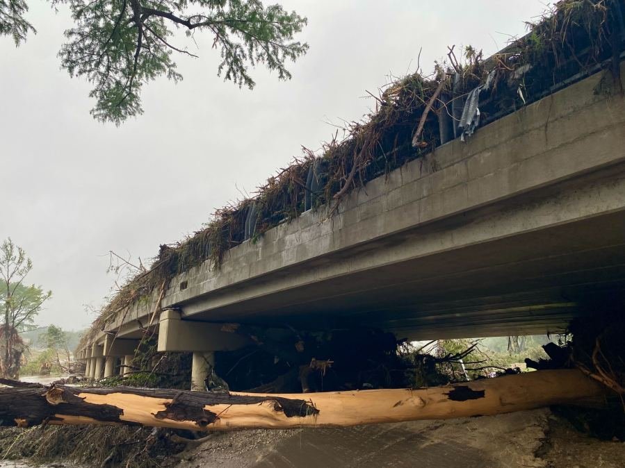
Localized LCRA rainfall totals in the region have exceeded 18 inches in some places.
The Guadalupe River in Kerrville measured just under a foot on Thursday, leading up to midnight. At about 4 a.m. Friday, the river rose over 30 feet in less than two hours, according USGS data.
Critical communication
On Friday, Lt. Gov. Dan Patrick also said during a separate press event that TDEM Region 6 Assistant Chief Jay Hall “personally contacted the judges and mayors in that area and notified them all of potential flooding.” KXAN has requested record of that communication to verify that statement and its level of urgency.

“Yesterday morning, the message was sent,” Patrick added. “It is up to the local counties and mayors under the law to evacuate if they feel a need. That information was passed along.”
NWS issued a flash flood warning at 1:14 a.m. Friday for a portion of Kerr County – where the majority of flood-related deaths have been reported. But it would be at least four hours before any county or city government entity posted directions to evacuate on social media.
City and county officials have yet to fully explain the timing of their Facebook posts surrounding the height of the flood or other ways they might have notified people near the water. Kerrville Mayor Joe Herring, Jr., said Saturday the city had done an “admirable” job making sure all information was available to the public. KXAN is awaiting responses after requesting records of communication between city, county and state officials to better understand decisions regarding their public warnings.
Kerr County Judge Rob Kelly has claimed officials “didn’t know this flood was coming.”
“This is the most dangerous river valley in the United States, and we deal with floods on a regular basis – when it rains, we get water,” Kelly said to reporters Friday. “We had no reason to believe this was going to be anything like what has happened here, none whatsoever.”
Kerrville City Manager Dalton Rice reiterated that apparent lack of awareness, telling the media Friday: “This rain event sat on top of that and dumped more rain than what was forecasted.”

Following those statements, the NWS provided additional details on its notification timeline for the Kerr County flood, including:
- The National Water Center Flood Hazard Outlook issued on Thursday morning indicated an expansion of flash flood potential to include Kerrville and surrounding areas.
- A flood watch was issued by the NWS Austin/San Antonio office at 1:18 p.m. on Thursday, in effect through Friday morning.
- The Weather Prediction Center issued three Mesoscale Precipitation Discussions for the excessive rainfall event as early as 6:10 p.m. Thursday indicating the potential for flash flooding.
- The National Water Center Area Hydrologic Discussion #144 at 6:22 p.m. on Thursday messaged locally considerable flood wording for areas north and west of San Antonio, including Kerrville.
- At 1:14 a.m. Friday, a flash flood warning with a considerable tag (which denotes high-damage threats and will automatically trigger Wireless Emergency Alerts on enabled mobile devices and over NOAA Weather Radio) was issued for Kerr County.
- The flash flood warning was upgraded to a flash flood emergency for southcentral Kerr County as early as 4:03 a.m. Friday.
- The 5:00 a.m. National Water Center Area Hydrologic Discussion #146 on Friday included concern for widespread considerable flooding through the day. The Flood Hazard Outlook was also upgraded to considerable and catastrophic.
- A flash flood emergency was issued for the Guadalupe River at 5:34 a.m.
KXAN is awaiting additional responses from the NWS on that timeline. KXAN also requested comments from Kidd and from NWS Austin/San Antonio Meteorologist in Charge Pat Vesper regarding how recent federal funding cuts might have impacted weather forecasting abilities in Texas.
TDEM responded but did not answer KXAN’s questions or indicate when Kidd would be available to speak directly about those issues. An NWS spokesperson said Vesper’s office “is focused on forecast operations right now, as flash flooding is ongoing.”
NWS staffing concerns
While state and local officials have not publicly – nor outright – blamed the Trump Administration’s financial decisions for any possible forecasting issues, public accusations on social media and elsewhere point to their timing during severe weather season.
For instance, directly under Vesper at the local NWS office is a key position – warning coordination meteorologist (WCM) – that has remained vacant since April. The role was most recently held by longtime employee Paul Yura, who took an early retirement package offered to agency workers as the administration worked to reduce the budget and personnel number at the NWS and its parent agency, the National Oceanic and Atmospheric Administration.
Yura, who KXAN recently reported spent more than half of his 32-year career at the local NWS office, gained tremendous experience understanding local weather patterns while ensuring timely warnings get disseminated to the public in a multitude of ways. The importance of his role as WCM cannot be understated.
Ensuring ample and timely warning to Central Texas counties was among the chief responsibilities. According to NOAA, “The WCM coordinates the warning function of the office with the outside world. This would include heading the Skywarn Program, conducting spotter training and being a voice to the local media for the office.”
Following the Kerr County flood, KXAN reached out to Yura – who referenced a hiring freeze in his retirement message to the media – but he referred questions to an NWS public affairs official.
Along with Yura’s job, five other vacancies in the local NWS office have stacked up, according to its online staff roster and the NWS Employees Organization. Those include two meteorologists, two technology staff members and a science officer. The office has 26 employees when fully staffed.
Federal funding and staff cuts
The administration made cuts to the federal workforce an early priority in Trump’s second presidential term this year, and those reductions extended to the NWS.
In May, NBC News reported the agency was working to shuffle employees to cover 150 positions that were vacated by the firings of probationary employees and early retirements of other longtime workers.
Some forecasting offices were left without overnight service, though no Texas offices were mentioned among those.
Tom Fahy, the NWSEO legislative director, then told NBC the staff cuts could increase risk and damage the agency’s ability to respond to a disaster.
Fahy told KXAN on Saturday the Central Texas flooding “was indeed a flash precipitation event,” leading to massive rainfall – something the local NWS office still had “adequate staffing and resources” to handle, despite its vacancies.
“They issued timely forecasts and warnings leading up to the storm,” he said, also referencing flood watches “out well in advance” the day before the waters rose.
In early June, the NWS was seeking to hire at least 126 people across the country, including meteorologists, following previous staff cuts, The Hill reported. A NOAA spokesperson told the outlet the NWS would be conducting “short term temporary duty assignments” and providing “reassignment opportunity notices” to fill field offices with the “greatest operational needs.”
The NWS Austin/San Antonio Weather Forecast Office currently has a 15% vacancy rate for meteorologists. The office’s total vacancy rate was 12% at the beginning of the year, but that increased to 23% by the end of April when employees took buyouts, Fahy confirmed to KXAN.
Federal officials visiting
President Trump posted on Truth Social he is “working with State and Local Officials on the ground in Texas in response to the tragic flooding,” ahead of U.S. Homeland Security Secretary Kristi Noem visit to represent the administration in Kerrville Saturday.
During a press conference after surveying the area, Noem told reporters the amount of rain in this flooding event was “unprecedented,” underscoring the reason Trump is working to “fix” aging technology within NOAA.
“I do carry your concerns back to the federal government and back to President Trump,” she said, acknowledging the need for upgraded technology to give “families have as much warning as possible.”
Central Texas flooding
Central Texas and the Hill Country are broadly known for major floods. With one of the highest risks for flash flooding in the country, the area has earned the nickname “flash flood alley,” according to LCRA.
This weekend’s tragedy isn’t the first.

In 1987, a flood hit the Guadalupe River, pushing the waterway up 29 feet and catching a church camp bus, according to the NWS. The bus, which was being used to evacuate dozens of children, was swept away and 10 children were killed.
Again, in 1998, flooding struck the region. On Oct. 17 and 18 that year a storm dropped roughly 30 inches of rain near San Marcos. Homes along the Guadalupe River near Canyon Lake and down to Seguin were washed off their foundations, NWS reported.
Closer to Austin, the Blanco River experienced catastrophic flooding in 2015 during the Memorial Day holiday weekend. Houses and bridges were washed away, and 13 people were killed across the region.