
Multi-Day Severe Weather Threat Is Building for the Plains and Mississippi Valley
The spring severe weather season is ramping up fast, and the NWS Storm Prediction Center is tracking a significant multi-day threat that will put major highway corridors across the central United States at risk beginning Monday, March 30, and continuing into midweek.
The SPC’s Day 4-8 Convective Outlook issued Friday morning identifies a strong signal for returning severe thunderstorm potential as a long-wave ridge de-amplifies and shifts east across the country. That shift will trigger steady lee troughing and cyclogenesis along the High Plains. Combined with a surface high off the East Coast pumping moisture northward from the Gulf, the setup creates the fuel for multiple rounds of severe storms across the Plains and Mississippi Valley through the week.
The Weather Prediction Center notes that strong to severe thunderstorms appear possible on multiple days as upper-level disturbances sweep across the growing moisture plume. Tornadoes, damaging winds up to 60 MPH, large hail, and heavy rain capable of triggering flash flooding are all threats on the table. Areas from Texas and Oklahoma through Arkansas, Louisiana, Tennessee, Kansas, and Missouri carry the highest risk through this period.
The I-35 and I-40 Corridors Are in the Bullseye
The geography of this setup places two of the country’s busiest highway corridors directly in the path of the developing threat.
I-35 runs from Laredo, Texas north through San Antonio, Austin, Dallas, Oklahoma City, Wichita, and Kansas City — the spine of Tornado Alley. I-40 cuts through Oklahoma City, Tulsa, Little Rock, Memphis, and Nashville — the heart of Dixie Alley. Both corridors sit within the zone the SPC is watching most closely as moisture return northward from the Gulf collides with strong upper-level flow this week.
Drivers making long-haul runs or interstate trips through any of these metros should monitor conditions actively before departure. Severe weather across these corridors can develop rapidly, and conditions on the road can go from clear to dangerous in minutes as storm cells move at 40 to 60 MPH.
A Tornado Watch — issued by the Storm Prediction Center when conditions are favorable for tornado development across a large area — is a distinct possibility for portions of this zone beginning Monday. A watch is not a warning, but it means drivers should have a clear plan if conditions deteriorate. When the SPC issues a Tornado Watch, it is time to identify nearby shelter points along your route, not wait to see what develops.
Getty / Feifei Cui-Paoluzzo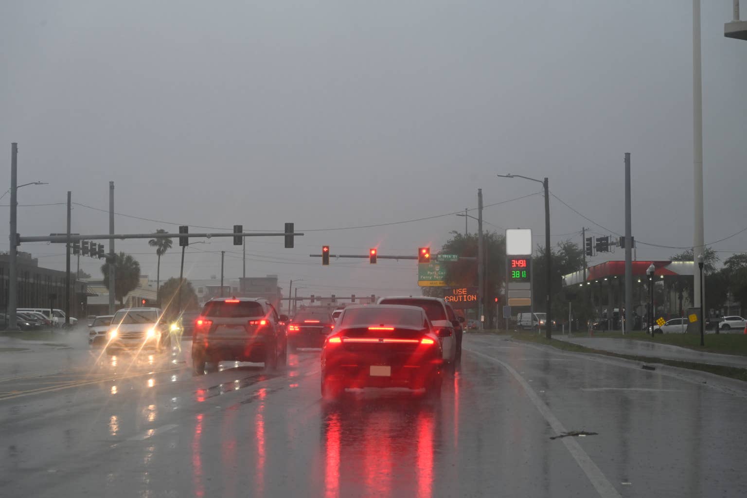
What Drivers Should Know
Do not underestimate the speed at which severe weather can make a highway impassable. In March’s outbreaks, multiple interstates in Indiana, Illinois, and Oklahoma saw rapid closures as tornado-warned storms crossed the road. In some cases, the warning window was less than five minutes from radar indication to confirmed touchdown.
If you are driving in the I-35 or I-40 corridor this week, these are your immediate action points.
Check the NWS Storm Prediction Center for the latest watch status before departure. If a Tornado Watch is in effect for your route, reconsider whether travel is necessary. If you are already on the road and a Tornado Warning is issued for your location, do not attempt to outrun the storm. Exit the highway, enter a sturdy building, and move to an interior room away from windows.
Never shelter under an overpass. This is one of the most dangerous places to be during a tornado. The overpass structure can funnel and intensify wind, and it offers zero protection from flying debris.
Severe thunderstorms outside of tornado-warned cells also pose serious risks on the highway. Rain rates of 2 to 3 inches per hour will reduce visibility to near zero in seconds. Wind gusts up to 60 MPH can push vehicles out of lanes and knock over high-profile trucks and trailers. Hail up to golf ball size and larger can shatter windshields without warning.
Speed reductions of 20 to 30 MPH below posted limits are appropriate when severe conditions are present. Turn on the headlights. Maintain extra following distance. If visibility drops to near zero, pull completely off the roadway, keep your seatbelt on, and activate your hazard lights until conditions improve.
Need New Tires? Save Up To 30% at Tire Rack
Find the perfect tires for your exact vehicle and driving style. Click here to shop all top-tier brands, including Michelin, Bridgestone, and more, directly at Tire Rack.
Keep An Emergency Kit In Your Vehicle
Severe weather season is the reminder to check and refresh your vehicle emergency kit. A basic kit should include a blanket, flashlight with extra batteries, phone charger or power bank, at least one bottle of water per occupant, non-perishable snacks, a basic first aid kit, rain poncho, and a paper map of your driving region in case cell service is lost.
Tires Are Your First Line of Defense
Severe weather season also means wet, slick roads — often with little warning. Your tires determine whether you can stop, steer, and maintain control when a storm hits.
If you are still running all-season tires from last winter or the season before, check tread depth now. The legal minimum is 2/32 of an inch, but 4/32 gives you meaningful wet-road capability. Use the quarter test: insert a quarter into your tread groove with Washington’s head facing down. If you can see the top of his head, your tires are approaching replacement range.