
Editors’ Vox is a blog from AGU’s Publications Department.
Earthquake surface ruptures can cause severe damage to infrastructure and, while preventative measures can be taken to allow the structures to adapt in the case of an earthquake, one of the best methods is to avoid unnecessary risks in the first place.
A new article in Reviews of Geophysics explores the history of Probabilistic Fault Displacement Hazard Assessments (PFDHA) and recent efforts to improve them with modern methods. Here, we asked the authors to give an overview of PFDHAs, how scientists’ methods have evolved over time, and future research directions.
What is fault displacement and what kinds of risks are associated with it?
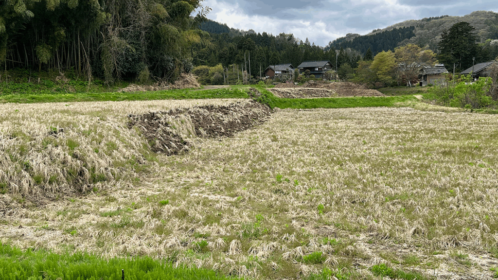
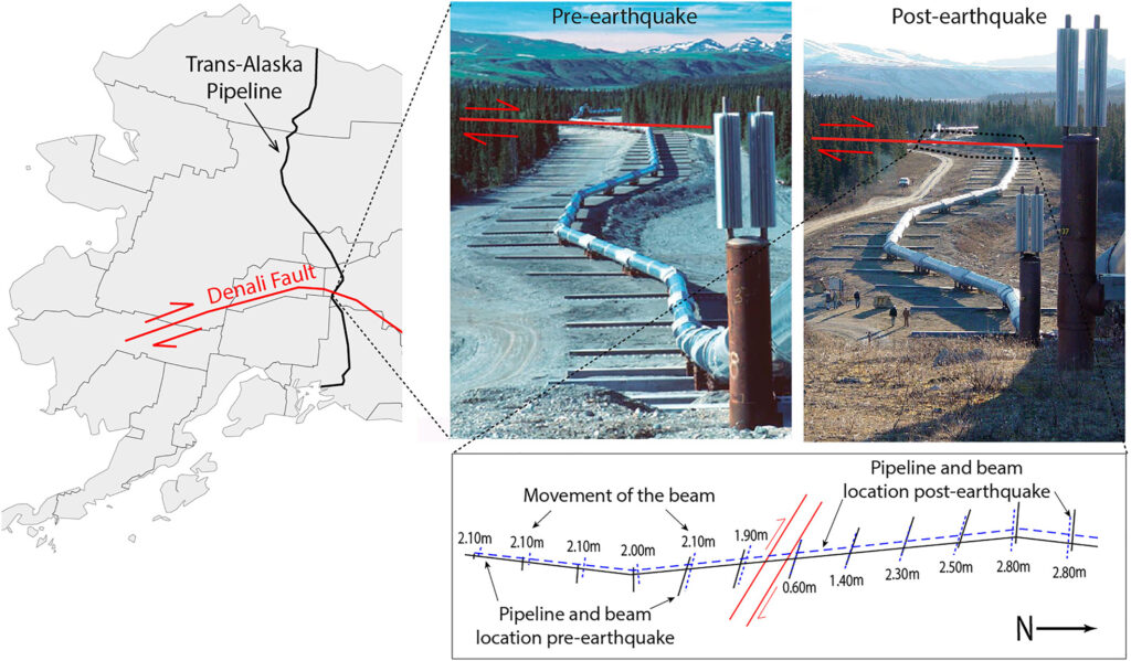
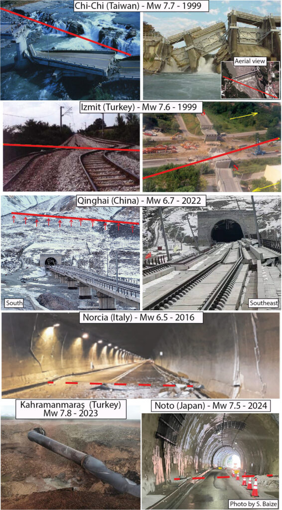
Fault displacement occurs when an earthquake breaks the ground surface along a fault. This displacement along the fault can shift the ground horizontally and/or vertically, by several meters for the largest earthquakes. Such ruptures pose serious risks to infrastructures located across faults—such as pipelines, transportation systems, dams and power generation facilities—because they may be torn apart or severely damaged. While some facilities can be engineered to tolerate limited movements, many critical systems are highly vulnerable, making it essential to evaluate this hazard.
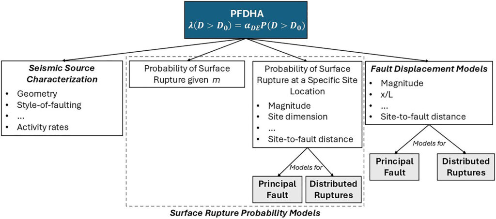
In simple terms, what are Probabilistic Fault Displacement Hazard Assessments (PFDHA)?
A Probabilistic Fault Displacement Hazard Assessment (PFDHA) is a quantitative analysis based on a method that estimates the likelihood that an earthquake will rupture the surface at a specific site and anticipate the magnitude of the displacement. Instead of giving a single answer, PFDHA provides probabilities of different displacement levels for different reference periods of interest. This allows engineers and planners to evaluate risks in a structured way and make informed decisions about building designs or land use near faults.
How have Fault Displacement Hazard Assessments evolved over time?
The first systematic PFDHA was developed in the early 2000s for the Yucca Mountain nuclear waste repository in the USA. Since then, the methodology has expanded from normal faults to include strike-slip and reverse faults worldwide. Over the past 25 years, new global databases of surface ruptures supporting statistical analysis, advances in statistical modeling, and international benchmark exercises have significantly improved the reliability and comparability of PFDHA approaches. In the future, the field should integrate remote sensing data, artificial intelligence, and physics-based modeling to better capture the complexity of earthquake ruptures.
What are the societal benefits of developing PFDHAs?
By quantifying the hazard of surface fault rupture, PFDHAs provide critical input for the safe design of infrastructures. This helps to avoid catastrophic failures such as pipeline leaks, dam collapses and resulting flooding, or road and railway disruption. Beyond engineering, PFDHAs also support land-use planning by identifying areas where construction should be avoided. Ultimately, these assessments reduce economic losses, improve resilience, and protect human lives in earthquake-prone regions.
What are some real-life examples of PFDHAs being developed and implemented?
One of the earliest and most influential applications was at Yucca Mountain, Nevada, where PFDHA helped assess the safety of a proposed nuclear waste repository. More recently, PFDHA approaches have been adopted internationally, including in Japan and Italy, for assessing risks to dams, tunnels, and other critical infrastructure.
What are some of the most exciting recent developments in this field?
Recent years have seen major advances thanks to new global databases such as the worldwide and unified database of surface ruptures (SURE) and the Fault Displacement Hazard Initiative (FDHI), which collect tens of thousands of observations of past surface ruptures. Remote sensing techniques now allow scientists to map fault ruptures with unprecedented detail. Importantly, these techniques have also awakened the geological and seismological community to the relevance of moderate earthquakes. Since the 2000s and 2010s, it has become clear that earthquakes smaller than magnitude 6.5 can also produce significant surface ruptures, a threat that was often overlooked before these technological advances. Additionally, international collaborations, such as the International Atomic Energy Agency benchmark project, are helping to unify approaches and ensure that PFDHAs are robust and reproducible across different regions.
What are the major unsolved or unresolved questions and where are additional research, data, or modeling efforts needed?
Several challenges remain. A key issue is the limited number of well-documented earthquakes outside North America and Japan, leaving other regions underrepresented in global databases. Another challenge is how to model complex, multi-fault ruptures, which are increasingly observed in large earthquakes. Understanding the controls on off-fault deformation, as revealed by modern geodetic techniques during large to moderate events, is another critical open question. This knowledge could improve our ability to predict rupture patterns and displacement amounts.
Similarly, the role of near-surface geology in controlling the location, size, and distribution of surface ruptures for a given earthquake magnitude remains poorly constrained and deserves further study. Standardizing terminology and methods is also essential for consistent hazard assessments. Looking forward, more high-quality data, integration of physics-based models, and improved computational frameworks will be crucial to advance the field.
—A. Valentini (alessandro.valentini@univie.ac.at, ![]() 0000-0001-5149-2090), University of Vienna, Austria; Francesco Visini (
0000-0001-5149-2090), University of Vienna, Austria; Francesco Visini (![]() 0000-0001-9582-6443), Istituto Nazionale di Geofisica e Vulcanologia, Italy; Paolo Boncio (
0000-0001-9582-6443), Istituto Nazionale di Geofisica e Vulcanologia, Italy; Paolo Boncio (![]() 0000-0002-4129-5779), Università degli Studi “G. d’Annunzio,” Italy; Oona Scotti (
0000-0002-4129-5779), Università degli Studi “G. d’Annunzio,” Italy; Oona Scotti (![]() 0000-0002-6640-9090), Autorité de Sureté Nucléaire et de Radioprotection, France; and Stéphane Baize (
0000-0002-6640-9090), Autorité de Sureté Nucléaire et de Radioprotection, France; and Stéphane Baize (![]() 0000-0002-7656-1790), Autorité de Sureté Nucléaire et de Radioprotection, France
0000-0002-7656-1790), Autorité de Sureté Nucléaire et de Radioprotection, France
Editor’s Note: It is the policy of AGU Publications to invite the authors of articles published in Reviews of Geophysics to write a summary for Eos Editors’ Vox.
Citation: Valentini, A., F. Visini, P. Boncio, O. Scotti, and S. Baize (2025), When the earth moves: 25 years of probabilistic fault displacement hazards, Eos, 106, https://doi.org/10.1029/2025EO255033. Published on 17 October 2025.
This article does not represent the opinion of AGU, Eos, or any of its affiliates. It is solely the opinion of the author(s).
Text © 2025. The authors. CC BY-NC-ND 3.0
Except where otherwise noted, images are subject to copyright. Any reuse without express permission from the copyright owner is prohibited.