Bomb Cyclone Targeting the Upper Midwest
The National Weather Service has issued Blizzard Warnings across seven states as one of the most significant late-season winter storms in years deepens rapidly and churns toward the Great Lakes. This system has the characteristics of a bomb cyclone, a storm that drops at least 0.71 inches of mercury in barometric pressure within 24 hours, generating an expansive, powerful wind field that can make road travel not just difficult, but life-threatening.
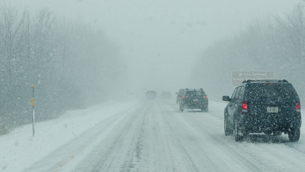
NWS Weather Prediction Center forecasters tracked the storm developing over Wyoming on Saturday, then intensifying across the northern Plains on Sunday and pushing into the Great Lakes region by Monday morning. The core of the snow band can produce 1 to 3 inches of snow per hour. Widespread totals of 1 to 2 feet are expected across the warning zone, with localized amounts exceeding 24 inches in northern Michigan and portions of Wisconsin. Wind gusts reaching 60 to 70 mph are forecast for major metro areas, including Minneapolis and Chicago, where whiteout conditions, sustained winds, and heavy snowfall that reduces visibility to a quarter-mile or less have already been reported.
The NWS Twin Cities/Chanhassen office called this a historic March winter storm, with one of the broadest Blizzard Warning footprints seen in the Upper Midwest in years. The warning language used by NWS forecasters is unambiguous: travel may become impossible. That is not hyperbole. It is the official NWS threshold language for conditions under which no vehicle should be on the road.
The Secondary System: Lake Effect and a Cold Air Hammer Behind the Storm
This storm is not a single event. It is the second of two powerful back-to-back systems to strike the region within 72 hours. The first system pushed through the northern tier on Saturday, generating wind gusts of 50 to 70 mph across the Upper Midwest and knocking out power to thousands of homes across Minnesota, Wisconsin, and northern Michigan.
Behind the storm, Arctic air will surge south starting Monday, driving afternoon highs into the teens and single digits across the Midwest and sending wind chills to near or below zero in cities like Minneapolis and Green Bay by early Tuesday. That post-storm cold punch will be its own hazard for drivers: any snow on road surfaces will harden rapidly, and roadway clearing that begins Monday afternoon could re-freeze overnight as temperatures crater.
Lake-effect snow bands are also expected to develop behind the storm as cold Arctic air crosses the still-open waters of Lakes Michigan, Superior, and Erie. Those bands can produce localized snowfall rates that rival the storm itself, and they often intensify after the main system has moved on, catching off-guard drivers who assume conditions have improved.
Regional Specifics: The Highways In the Bullseye
The NWS Minneapolis forecast office has issued Blizzard Warnings for central and southern Minnesota through Monday morning. The I-94 corridor from Minneapolis westward toward Fargo and eastward toward the Wisconsin border faces especially dangerous conditions Sunday night. The I-35 corridor through southern Minnesota is at risk of a wintry mix of freezing rain, sleet, and snow transitioning to full-blizzard conditions as the storm system tracks through.
In Wisconsin, the NWS has flagged Highway 2 along the Lake Superior South Shore as particularly dangerous, with whiteout conditions described as “treacherous and potentially life-threatening.” US-2 runs along the southern edge of Lake Superior through Iron, Ashland, and Bayfield counties, some of the highest snowfall counties in the region, and should be considered impassable for non-emergency travel through Monday.
In northern Michigan, the NWS Gaylord office is forecasting 15 to 24 inches of snow across the Upper Peninsula, including Alger, Marquette, and Luce counties, with wind gusts up to 60 mph near Lake Superior. Highway M-28, the primary east-west spine of the Upper Peninsula, will face whiteout conditions and potential closure. The Keweenaw Peninsula, north of Houghton, faces the state’s most extreme wind threat, with gusts forecast up to 65 mph.
In South Dakota and southwest Minnesota, Blizzard Warnings cover a broad zone stretching from Watertown and Brookings, South Dakota, through Marshall and Worthington, Minnesota, with the I-90 corridor at risk for dangerous driving conditions through Sunday evening.
Across Illinois and Iowa, the NWS Storm Prediction Center and NWS Des Moines office have warned of blizzard conditions Sunday into Monday morning, with the I-90/I-94 corridor and I-80 through Iowa in the warning zone. Chicago and the northern Illinois I-90/I-94 corridor have already experienced 60 to 70 mph wind gusts from the preceding system and face additional accumulating snow as the bomb cyclone deepens Sunday night.
What Drivers Should Know
The NWS has issued explicit guidance that travel should be restricted to emergencies only across the Blizzard Warning zones. If you are in Minnesota, Wisconsin, northern Michigan, South Dakota, Iowa, northern Illinois, or Montana, do not drive unless your situation constitutes a genuine emergency.
If you are planning to drive ahead of or around the storm’s edges, reduce your speed by at least 30 percent below the posted limit on any snow-covered roadway. On interstates in active blizzard conditions, many state transportation departments recommend maximum speeds of 30 to 35 mph. Do not use cruise control on any road surface that may be slick. Cruise control cannot react to the sudden loss of traction that occurs on ice or packed snow, and it can cause wheel spin that leads to an uncontrollable skid.
Whiteout conditions are particularly dangerous on long, straight sections of interstate highways because they can cause spatial disorientation, and drivers lose the ability to judge their lane position or the presence of vehicles ahead. The standard guidance is to pull off the road, activate your hazard lights, and wait. If you cannot safely reach an exit or rest area, pull as far onto the shoulder as possible. Do not stop in a travel lane.
High-profile vehicles, such as SUVs, pickup trucks, vans, and RVs, face an additional hazard from extreme crosswind gusts in the 60-70 mph range. At those wind speeds on exposed interstate stretches, lateral force on a high-profile vehicle is enough to cause a lane departure or rollover without warning.
Keep An Emergency Kit In Your Vehicle
Anyone traveling in the Blizzard Warning zone should carry a dedicated winter emergency kit. That means a wool or mylar blanket (or both), a flashlight with fresh batteries, a portable phone charger, at least one liter of water per occupant, non-perishable snacks, a basic first aid kit, a folding shovel, and a bag of sand or kitty litter for traction if you get stuck. If you are traveling on any mountain or elevated route, including passes in Montana or elevated terrain in northern Michigan, tire chains are required equipment, not optional.
If you get stranded, the NWS and state transportation departments are uniform in their guidance: stay with your vehicle. A car is easier for search and rescue to locate than a person on foot. Running the engine for heat is acceptable, but crack a window slightly and periodically clear snow from around the exhaust pipe to prevent carbon monoxide buildup.
Tires Are Your First Line of Defense
In blizzard conditions, no vehicle system matters more than the four contact patches between your tires and the road. All-season tires are legal in all 50 states and adequate for mild winter driving, but they are not designed for sustained blizzard conditions. A tire rated with the Three-Peak Mountain Snowflake (3PMSF) symbol has been tested to perform in severe snow and meets a minimum traction threshold that standard all-season tires do not.
Tread depth is the other critical variable. The legal minimum tread depth in most states is 2/32 of an inch, but tire engineers and safety organizations recommend replacing winter tires at 4/32 of an inch, because stopping distance increases dramatically below that threshold on snow and ice. The quick test: place a quarter upside down in your tread groove. If you can see the top of Washington’s head, your tires are approaching the danger zone.
Cold temperatures also reduce tire pressure. For every 10-degree Fahrenheit drop in ambient temperature, tire pressure drops approximately 1 to 2 PSI. With temperatures falling 15 to 25 degrees below normal behind this storm, a tire that was properly inflated last week may now be running significantly underinflated — reducing contact area, handling precision, and braking performance at exactly the moment you need them most. Check your tire pressure before any trip into winter storm conditions.