Snow is falling in the high country today, and forecasters at the National Weather Service expect the heaviest totals on the tallest peaks through Sunday evening. The official forecasts put most mountain passes at an inch or two, while the high end of the range climbs past a foot on exposed summits. Anyone planning a mountain drive or an early ski trip will mostly see the smaller totals, since the passes sit well below the summits.
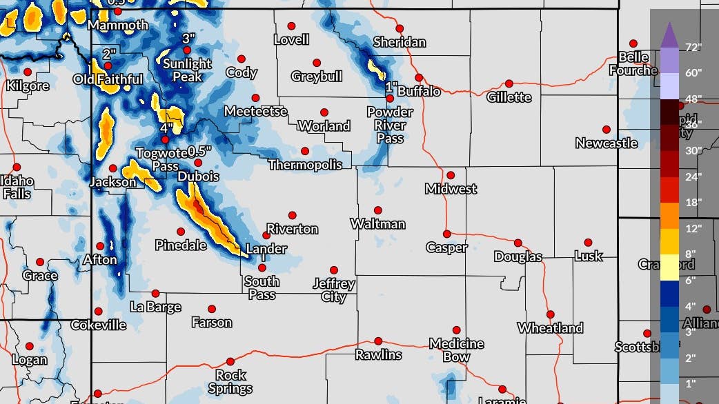
The high end of the forecast range, which NWS Riverton puts at a 1 in 10 chance of being exceeded, reaches 17 inches on Gannett Peak
Wyoming Has The Highest Totals
NWS Riverton’s probabilistic snowfall forecast map, issued at 5:21 a.m. ET Friday and valid through 8 p.m. ET Sunday, expects 7 inches on Gannett Peak in the Wind River Range. On the high end map, which shows totals with a 1 in 10 chance of being exceeded, a narrow band along the crest of the range reaches 18 to 24 inches, and Gannett Peak itself could see 17. Wind River Peak is forecast at 4 inches and could reach 13, and the Grand Teton could pick up 5 to 10 inches. In the high country of southern Yellowstone, Moose Basin Divide and the Pitchstone Plateau are each forecast at 4 to 5 inches, with a high end of 11.
Utah, Idaho And Colorado
NWS Salt Lake City expects 5 inches on Kings Peak in the Uintas, with a high end of 10, while Snowbird is forecast at an inch with a chance of up to 8. In central Idaho, NWS Pocatello gives Hyndman Peak 4 inches and a high end of 12, and 4th of July Peak 3 inches with a high end of 10. Colorado’s San Juan Mountains see the most in that state, though NWS Grand Junction now expects only 3 inches on Red Mountain Pass, down sharply from Thursday’s outlook, and a 1 in 10 chance of 8.
Montana Advisories Through Friday Night
NWS Great Falls expects less than 2 inches in most towns through Saturday morning, with 1.9 inches at Geyser and 1.5 at Lewistown, and Winter Weather Advisories cover several mountain ranges from Friday afternoon into early Saturday. NWS Missoula’s advisory for MacDonald Pass on US-12, Homestake Pass on I-90 and Georgetown Lake calls for a trace to 3 inches and warns of slippery roads for the Friday evening commute.
What It Means On Mountain Passes
Most of the roads that drivers will actually use will stay at the low end of the forecast. NWS Riverton expects 2 inches on Sylvan Pass, the road through Yellowstone’s East Entrance, and an inch each on Togwotee Pass and Teton Pass. In Colorado, Wolf Creek Pass on US-160 is forecast at an inch, and Galena Summit on Idaho’s Highway 75 could see a trace to 4 inches.
Even an inch on a pass after dark can leave a lane slick, especially on bridges and shaded curves where fresh snow lingers. Our winter tire guide covers what to check before a mountain trip.