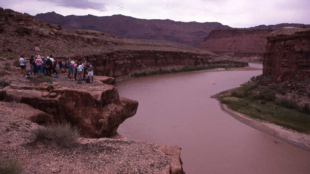
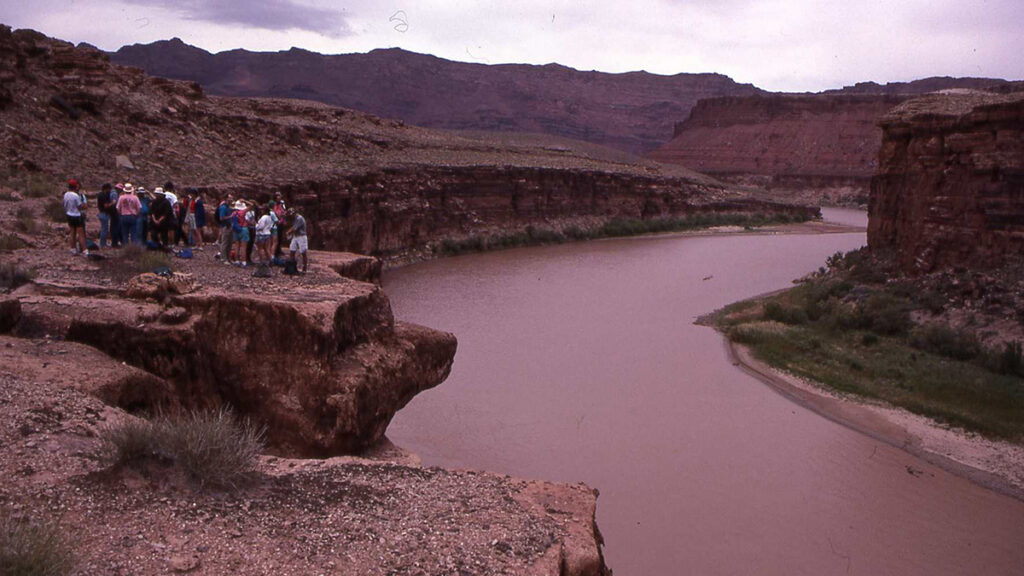
In May 1992, a group of scientists gathered at the edge of Marble Canyon in northern Arizona, where the Colorado River has cut into Permian sandstone to form cliffs that rise hundreds of feet above the water. The occasion was the First International Workshop on Paleoflood Hydrology, organized by Vic Baker of the University of Arizona. For Baker and his colleagues, the canyon walls were not just scenery. They were a kind of archive.
Here, sediment deposits mark the high-water lines of floods that surged through the canyon centuries before any stream gauges were there to measure them. In particular, Baker and his colleagues studied slackwater deposits, fine-grained sediments emplaced by floodwaters in sheltered alcoves and tributary mouths.
Over the course of decades, Baker, together with collaborators and students, developed methods to read the Marble Canyon deposits. Researchers used hydraulic models to back-calculate past flood discharge and used radiocarbon dates to pinpoint when floods occurred. Their analyses revealed floods that were nearly twice the size of those captured by the instrumental record and that recurred far more frequently than engineers had assumed [Greenbaum et al., 2014].
Baker and his collaborators also mapped out statistical frameworks to translate their data into flood frequency estimates that present-day engineers and water managers could use.
The U.S. Bureau of Reclamation put those data to use, incorporating the long flood history written on the canyon walls into formal hazard assessments for dam safety and infrastructure design on the Colorado River. The logic was straightforward: The biggest, most destructive floods are also the rarest, which means they are routinely missing from the short instrumental records engineers rely on, leading to dangerous underestimates of risk.
Expanding the Field in Breadth and Depth
In the decades since Baker helped establish paleoflood hydrology as a discipline, the field has expanded to encompass a much wider range of settings and methods, including boulder berms in mountain rivers, alluvial fills in lowland valleys, tree ring “flood rings” in riparian (riverbank) forests, detrital layers on stalagmites in caves, and historical archives stretching back centuries in regions with long written records, to name just a few.
The study of riverine flooding represents just one of several fields that use geological records to improve hazard assessments.
A landmark synthesis by Wilhelm et al. [2019] documented this methodological diversity across flood settings worldwide. Each approach requires its own deep disciplinary expertise and preserves different aspects of flood history. The approaches vary considerably in the precision and accuracy of the estimates they produce, and not all have matured to the point where their outputs can be directly incorporated into formal hazard assessments in the way Baker’s analyses of slackwater deposits were.
Moreover, the study of riverine flooding represents just one of several fields that use geological records to improve hazard assessments. Want to reconstruct the history of tropical cyclones and coastal storms? Paleotempestology uses sediment cores from coastal ponds and sinkholes, and isotopic signatures preserved in tree rings, to do just that. Need to understand how often a fault experiences a major earthquake? Paleoseismology reads fault scarps, liquefaction features, disturbed stratigraphy, and tsunami deposits to find out.
Each of these fields has its own methods, its own archives, its own hard-won expertise—its own Vic Bakers. And each faces the same fundamental challenge: translating qualitative or semiquantitative evidence of past events into the precise, uncertainty-bounded estimates that planners, engineers, and risk managers can use.
A Proposed Center for Paleoenvironmental Records of Extreme Events
A new report from the National Academies of Sciences, Engineering, and Medicine (NASEM) [2026] (“A Synthesis Center for Paleoenvironmental Records of Extreme Events”) represents a welcome and timely recognition that these fields have something important to offer. Despite decades of progress, the report finds, these long-term records of extreme events remain underused by the agencies, industries, and communities that manage risk.
The report proposes a new center with a mandate to “focus on the integration, synthesis, and translation of paleoenvironmental data.” The report envisions this work carried out through mission-oriented working groups spanning academia, government, and industry. This is a laudable structure, given how disconnected these communities’ incentives and timelines often are.
But this framing raises a fundamental question: Is the primary barrier to translation really a lack of synthesis? Or is it that most of these records have not yet reached the standard that made Baker’s analysis of slackwater deposits useful to the Bureau of Reclamation?
The answer, I would argue, is that the quality of the records themselves represents a fundamental barrier to bridging the translational gap. The report recognizes this, at least implicitly, by distinguishing “Tier 1” records (those that provide quantitative, precise estimates of past hazard magnitudes directly comparable to instrumental data) from lower-quality records. It also acknowledges that such records are rare.
Across most settings and hazard types, the majority of existing records of paleoenvironmental hazards fall short of the Tier 1 standard.
Across most settings and hazard types, the majority of existing records of paleoenvironmental hazards fall short of the Tier 1 standard. This matters enormously, as incorporating paleoflood estimates with large errors into flood frequency analysis increases uncertainties rather than reducing them [Reinders and Muñoz, 2021].
Records need to meet a quality threshold—roughly 20% error or less—to help rather than hurt. Synthesizing records that fall below that threshold widens the translational gap instead of closing it.
In addition to quality, these records face a second challenge that resists synthesis: They are, by their very nature, site-specific. What gets recorded at a given site depends on factors that can vary enormously over short distances—the geometry of a canyon, the height and orientation of a beach barrier, the elevation of a tree in a floodplain.
Two nearby sites on the same river can preserve fundamentally different flood histories, not because the floods were different, but because local geomorphic conditions controlled what was recorded and preserved. This site specificity is simply how these archives work.
Site specificity means that such records resist the kind of broad synthesis that works well for more standardized data types. Aggregating them in a database does not produce a clean regional picture of hazard frequency and magnitude. Rather, it produces a collection of site-specific stories that require deep disciplinary expertise to interpret, compare, and contextualize.
A Path Forward: Investing in Methods and People
There are promising methodological pathways to elevate records toward a quality that practitioners can use. My lab, which focuses on hydrologic extremes across a range of settings and timescales, has worked on integrating paleoenvironmental records with physical model simulations. Such simulations enable researchers to move beyond qualitative or semiquantitative evidence and toward precise, uncertainty-bounded estimates of hazard magnitude. Other frontiers exist across geochronology, proxy development, and statistical frameworks.
In paleoflood hydrology, hydraulic models can simulate the water levels, velocities, and depositional conditions associated with floods. This ability links sediment properties directly to flood magnitude and reduces uncertainties in paleoflood estimates [Reinders et al., 2023].
The number of labs actively producing high-quality paleoenvironmental records of extreme events, and advancing the methodologies to improve them, remains small.
In paleotempestology, overwash deposits in coastal ponds record when hurricanes occurred, but not their tracks or magnitudes. Coastal hydrodynamic and morphodynamic models offer a promising path to fill that gap, back-calculating storm surge magnitudes from the sedimentary deposits that storms leave behind. Site-specific factors such as sea level change and barrier morphology present real challenges, but the approach shows promise and warrants sustained investment.
Developing these methods requires a strong professional cohort. Here, the field faces a compounding challenge. The number of labs actively producing high-quality paleoenvironmental records of extreme events, and advancing the methodologies to improve them, remains small. This means there are few graduate students and postdoctoral researchers trained in these approaches, few experienced reviewers for papers and proposals, and a limited capacity to evaluate whether new work is actually meeting the quality threshold that translation of paleoenvironmental data requires.
The NASEM report itself names education and training as a core function of the proposed center, envisioning opportunities for postdoctoral researchers, students, and visiting scholars. Training researchers who understand both the science and the needs of practitioners—those who speak the languages of both sedimentology and flood frequency analysis, for example, or stratigraphy and storm surge modeling—is exactly what government agencies and industry partners need, and exactly what would make a center so valuable.
A Center Worth Building
A center dedicated to paleoenvironmental records of extreme events is an idea worth pursuing. Its design, however, will determine whether it actually closes the translational gap it aims to address.
What such a center could accomplish would differ fundamentally from what any single lab can. One group can advance one method for one hazard type, but a center could convene parallel working groups across hazard types, drawing together expertise currently dispersed across a small number of labs and sustaining training pipelines beyond the durations of individual grants. The National Center for Ecological Analysis and Synthesis and the National Socio-Environmental Synthesis Center are both National Science Foundation–funded synthesis centers built on a convening structure. They offer templates for how such a center might be organized and hosted.
I recommend that such a center explicitly prioritize methods development and workforce training alongside synthesis and translation.
I recommend that such a center explicitly prioritize methods development and workforce training alongside synthesis and translation.
This means funding graduate and postdoctoral fellowships and sabbatical residencies that convene early-career scientists, established researchers, and practitioners. Working together, these groups can develop approaches to elevate records toward more effective translation across disciplines and professions.
It means establishing working groups organized around specific hazard types and methodological approaches, each charged with developing and disseminating best practices and evaluating what it takes to produce records that practitioners can use.
And it means recognizing that these same sectors have a direct stake in this investment. Such partners include the Federal Emergency Management Agency, the U.S. Army Corps of Engineers, and the insurance and catastrophe risk industries. These sectors need researchers trained to speak the languages of both science and industry, and cofunding a center that produces them would serve the interests of both communities.
The scientists who gathered at Marble Canyon in 1992 had spent decades building the foundation that made their work useful. The proposed center offers an opportunity to accelerate that process across a much wider set of hazards and settings, but only if it invests in the foundation first.
References
Greenbaum, N., et al. (2014), A 2000 year natural record of magnitudes and frequencies for the largest Upper Colorado River floods near Moab, Utah, Water Resour. Res., 50(6), 5,249–5,269, https://doi.org/10.1002/2013WR014835.
National Academies of Sciences, Engineering, and Medicine (NASEM) (2026), A Synthesis Center for Paleoenvironmental Records of Extreme Events, 132 pp., Natl. Acad. Press, Washington, D.C., https://doi.org/10.17226/29290.
Reinders, J. B., and S. E. Muñoz (2021), Improvements to flood frequency analysis on alluvial rivers using paleoflood data, Water Resour. Res., 57(4), e2020WR028631, https://doi.org/10.1029/2020WR028631.
Reinders, J. B., et al. (2023), A hydraulic modelling approach to study flood sediment deposition in floodplain lakes, Earth Surf. Processes Landforms, 48(4), 756–769, https://doi.org/10.1002/esp.5515.
Wilhelm, B., et al. (2019), Interpreting historical, botanical, and geological evidence to aid preparations for future floods, WIREs Water, 6(1), e1318, https://doi.org/10.1002/wat2.1318.
Author Information
Samuel E. Muñoz (s.munoz@northeastern.edu), Department of Marine and Environmental Sciences, Northeastern University, Nahant, Mass.; and Department of Civil and Environmental Engineering, Northeastern University, Boston
Citation: Muñoz, S. E. (2026), Prioritizing quality before synthesis in paleoenvironmental hazard science, Eos, 107, https://doi.org/10.1029/2026EO260275. Published on [DAY MONTH] 2026.
This article does not represent the opinion of AGU, Eos, or any of its affiliates. It is solely the opinion of the author(s).
Text © 2026. The authors. CC BY-NC-ND 3.0
Except where otherwise noted, images are subject to copyright. Any reuse without express permission from the copyright owner is prohibited.