At the Royal Museum for Central Africa on the outskirts of Brussels are four monumental wall maps from 1910 depicting Belgian colonial interests. They are dense with information: the exchange rates of resources, pricing structures tied to extraction, and, more chillingly, the market value assigned to enslaved people. These were not simply records of an empire, but instruments that diagrammed how land could be occupied and made profitable. It’s an image that stuck with me since I first saw them last winter — perhaps because it’s the clearest example I have seen of violence embedded in systems of land measurement, but also because they were originally installed to persuade viewers to invest in the enterprise of Belgium’s colonial expansion. Protected by national heritage laws, they remain fixed to the walls, now serving as the backdrop to displays of objects and resources acquired, in part, through the extractive logic they encode.
Maps appear objective, yet they are built from choices that frame a particular view of the world. They are doubly instructional in the knowledge they share and in the ways they orient the viewer, offering a surface on which land appears ordered, bounded, and knowable. A run of recent exhibitions in New York of the works of late Venezuelan conceptual artist Claudio Perna, Chicano artist Sandy Rodriguez, and Dominican artist Firelei Báez brings that charged surface into focus across generations of artists who take up cartography’s capacity for orientation and put it to work otherwise: turning maps from tools of classification into frameworks for examining movement, memory, and power.
For Claudio Perna, this takes the form of a sustained engagement with Venezuela, where he lived most of his life and which he mapped most insistently. Born in Milan, he moved to Caracas at 17, where he trained as a geographer and later taught at Universidad Central de Venezuela — bringing a disciplinary understanding of territory that he would repeatedly unsettle in his artistic practice. Between the late 1960s and early 1990s, Perna produced an extensive series of map-based works that treat cartography not as a neutral technology of fact, but as an authored and unstable document. Idea como Arte, a recent exhibition of Perna’s work at the Institute for Studies on Latin American Art, presented photographs, xeroxes, and a selection of maps from this period that range from the diaristic — works incorporating photographs of the artist himself — to dense collages assembling magazine clippings, projection slides, and other objects.
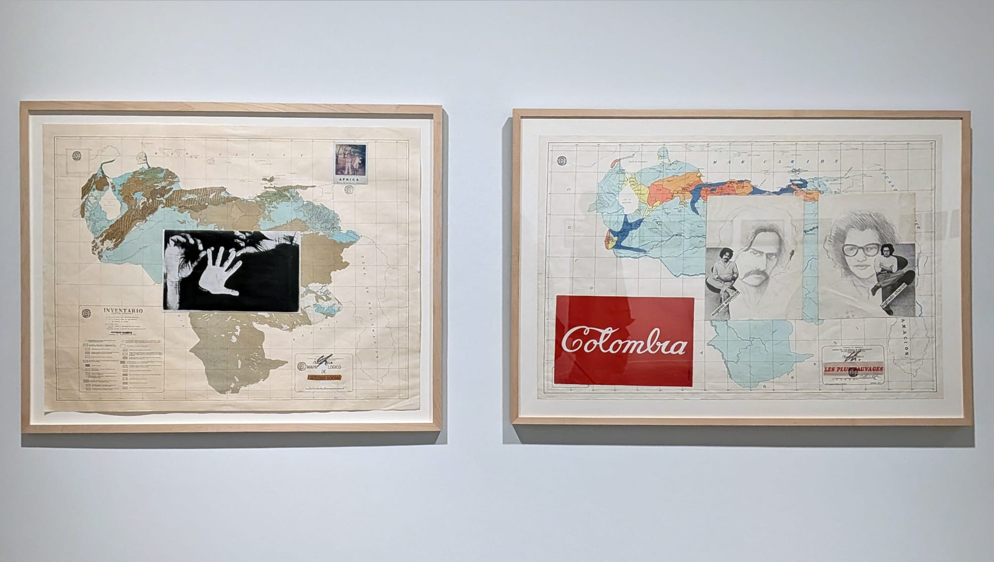
There is a friction between the layers Perna assembles, as in “The Americas” (undated), where the continental landmass is overlaid with the lunar surface, suggesting a parallel between exploration and claim. Elsewhere, Perna introduces more specific markers of foreign presence within a mapped terrain. In “Les Plus Sauvages—Colombia” (1977), he builds over a map of hydraulic resources spanning the Venezuelan-Colombian border, layering in references to artists from either side. He affixes portraits of Venezuelan artists Sigfredo Chacón and Eugenio Espinoza, figures associated with the imported and nationally dominant language of geometric abstraction; Espinoza more explicitly “tropicalized the grid” to resituate it locally. On the other side of the border appears a reproduction of “Colombia Coca-Cola” (1976) by Antonio Caro, which renders the country’s name in the cursive script of the “bottled America” soft drink brand. As in Caro’s original, the gesture collapses national identity into corporate branding, invoking the reach of United States capitalism across Latin America during the Cold War, often described as “Coca-Colonization.” Within Perna’s composition, the logo functions almost like a cartographic label, as if the name of the nation itself has been overwritten by a corporate sign. The Cold War context is specific, but US influence and presence in Latin America now feels less historical than continuous.
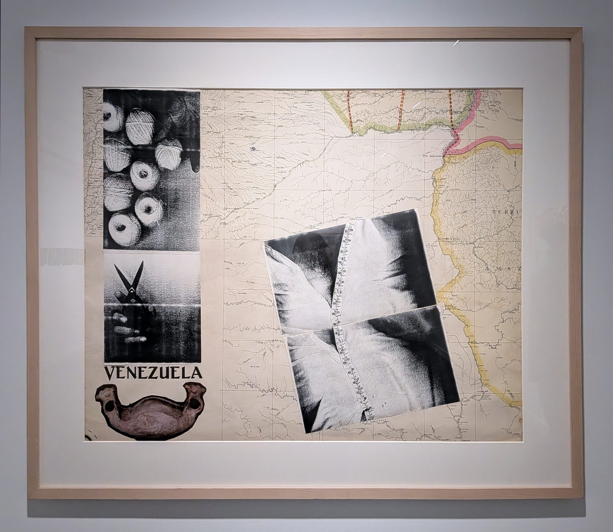
There is a migrant sensibility to attempting to chart an unstable, fluid relationship to territory — at times, it looks like grasping for belonging from without rather than within. In “Venezuela” (undated), a cross-section of the southern Colombia-Venezuela border becomes the ground for a series of collaged elements, including photographs of threads, scissors, and a vertebra — objects that suggest cutting and binding, even a kind of suturing. A self-portrait of Perna’s torso appears next to the border, a line of buttons running parallel to it. The image, along with the collaged elements, gathers on the Colombian side, as if the artist is physically severing associations with Venezuela.
Here, Perna composes a condition of exteriority, an untethered relation to the country that resonates with the experience of the immigrant. That outsideness is now a structural reality for many: A country that once welcomed migrants in significant numbers has, in recent decades, become one of the largest sources of displacement in the world, with nearly 8 million Venezuelans, or a quarter of the population, living abroad. I first saw this work in the Foreigners Everywhere exhibition at the 2024 Venice Biennale, a show structured around the condition of being a foreigner, whether migrant, exile, or outsider. Encountering it again now — outside of Venezuela, as before — sharpens the sense that Venezuelan art has been afforded a freedom of movement across borders that is denied to many of its people.

Movement, and its obstruction, is subject to monitoring in Sandy Rodriguez’s current exhibition at the Hispanic Society Museum & Library, Tierra Insurgente. Drawing on Mesoamerican traditions of the spatialization of time, she produces contemporary codices that assemble historical events, mythic references, and acts of state violence, distributed spatially so that the map operates as a record of memory. Events that are temporally distant from one another are made to coexist within a single visual field, and in that proximity, they begin to register as part of a continuous historical arc.
Tierra Insurgente stages a set of correspondences between Rodriguez’s work and the museum’s collection of maps and manuscripts. One of the clearest pairings involves “Map of Tequaltiche” (1584), produced by Caxcan artists as part of a geographic report submitted to the Spanish Crown, under a decree by Philip II. The map records the town’s participation in a 1541 rebellion against colonial rule, embedding an account of resistance into a format designed for imperial reporting. In “Resistance Map of Gulf of Mexico” (2025), Rodriguez’s rendering of the recently renamed basin takes up a related countermapping strategy. Political actors appear as mythic or monstrous forms: Governor Ron DeSantis as a sea creature, Trump’s severed head caught in the tentacles of an octopus. Contemporary state violence sits alongside environmental catastrophe, marking the steady rise of sea levels and the trajectory of Hurricane Katrina. She borrows scenes of Spanish arrival from the Tequaltiche map and images of pre-contact Aztec omens — tongues of fire in the sky — that echo the apocalyptic wildfires in California. Where the Aztec notion of the omen remains useful for us is not as prophecy but as a way of understanding how warning signs gather before recognition catches up.
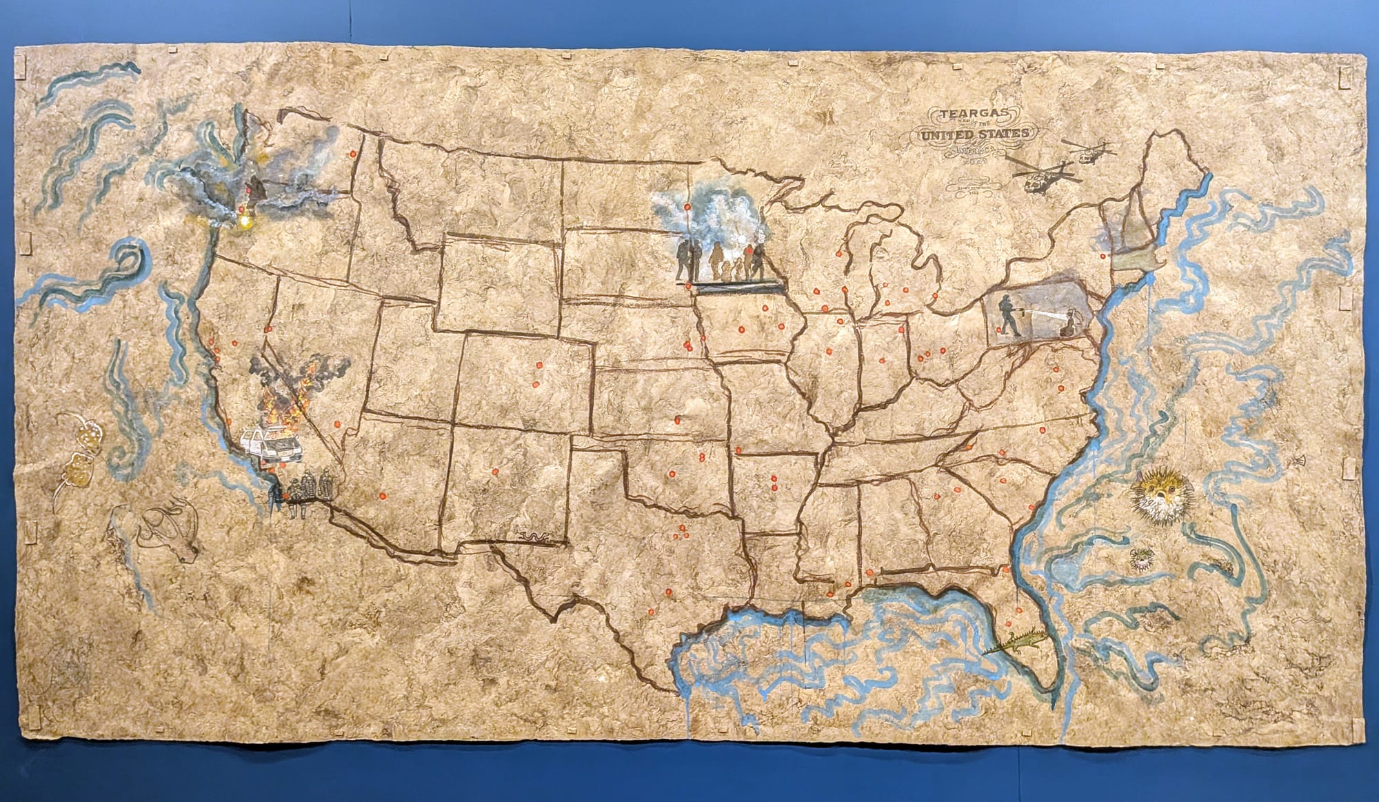
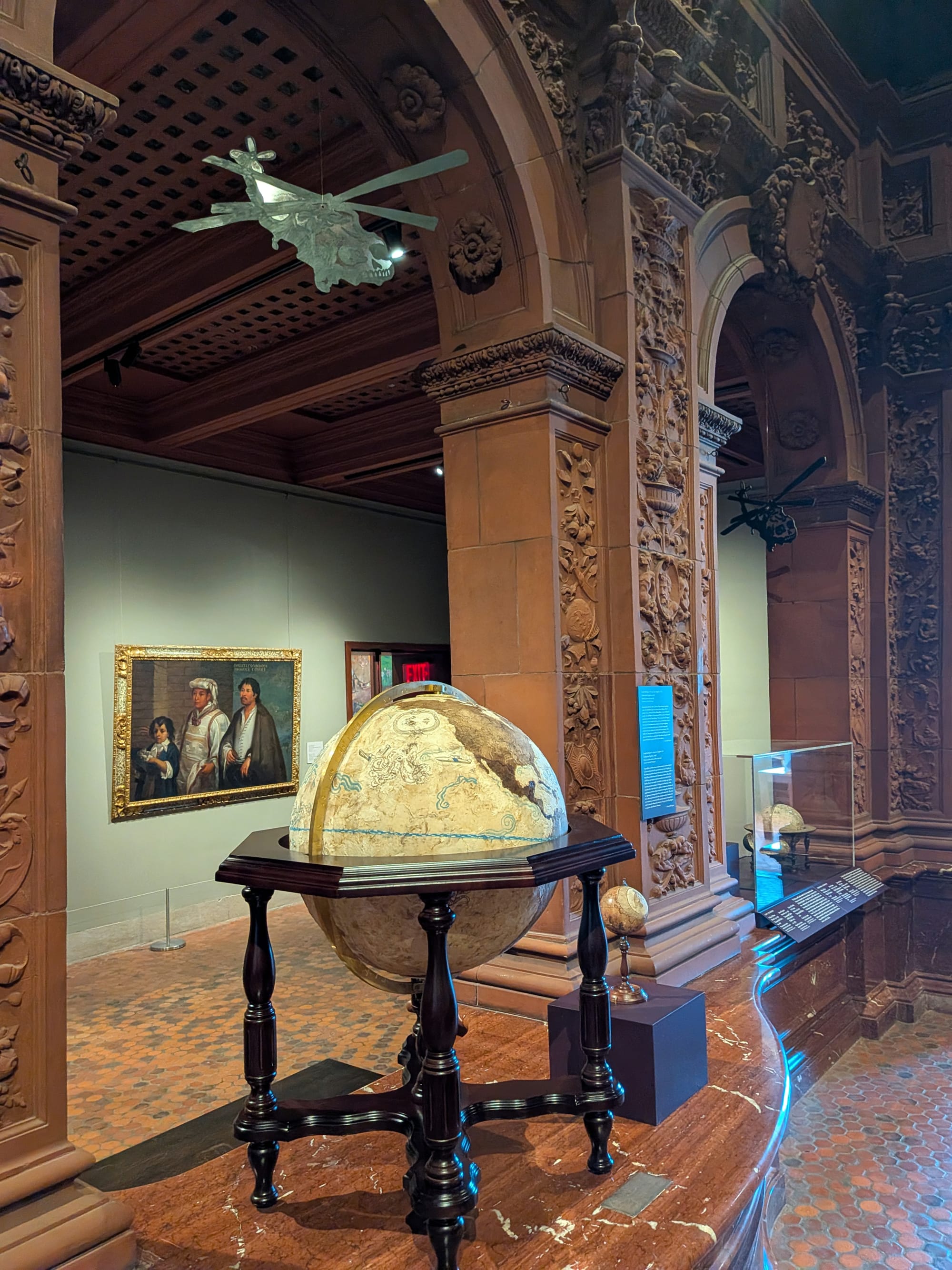
Sometimes, it is only in their accumulation that repeated tragedies come to register as crisis. In “Tear Gas Map of the United States of America” (2020–24), Rodriguez plots sites of militarized response to protests against police violence. The work’s force lies as much in its materials as in its marks: A wall label explains that red ocher carries associations of inscription; cochineal registers intertwined histories of extraction and blood. Updated over four years, the work operates as a living record, its field of red dots steadily populating the map like a countermapping — a reversal in which surveillance produces a record of the state rather than its subjects. Suspended from the gallery’s arches, the “calavera copters” are skeletal helicopters hovering overhead like an uneasy reminder of aerial control. Below one of them, “Third-Country Deportations Globe” (2026) tracks third-country deportations under the current US federal administration.
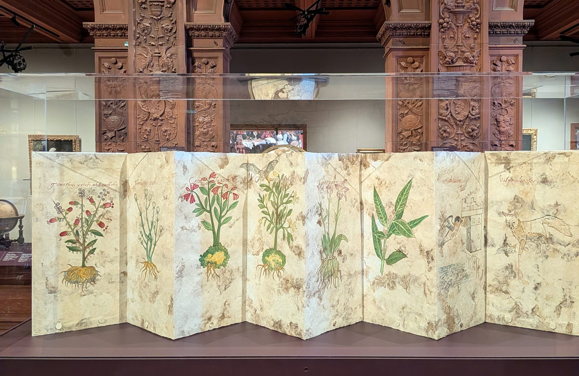
Rodriguez’s works register how space is controlled and monitored, but they also propose another relationship to land that is grounded in Indigenous knowledge systems. The exhibition brings together landscapes, protest scenes, maps, and botanical studies created with her hand-processed pigments from native plants and hand-made amate paper. Plant knowledge — historically extracted and systematized through colonial taxonomies — reappears here not as data, but as a material practice of recording and remembering.
Firelei Báez takes up a similar recovery of folklore and diasporic memory against the grain of colonial archives at her current solo exhibition at Hauser & Wirth, feet squelching on wet grass, nourished by uncertainty. Báez directly borrows and paints on top of 19th-century cartographic documents, producing works in which the colonial underlayer is overgrown by bodies, plants, and mythic figures. One piece builds atop Emma Willard’s “Chronographer of American History” (1846), a timeline rendered as a map, with limbs and tendrils spilling across the surface, exceeding its orderly structure. Elsewhere, in “View of Nature” (2026), she takes John Emslie’s 1852 engraving of climate gradations from the equator to Arctic Circle and saturates it with poured paint that pools into tropical foliage and dissolving light. Here, like in many of Báez’s monumental paintings, schematic measurements and text are submerged behind chimeric figures. These presences — drawn from Afrodiasporic cosmologies, Caribbean folklore, and botany — may originate from legend, but the documents underneath are themselves a kind of fantasy, or in the artist’s own words, “projections of desire.”
In Báez’s hands, maps cease to function as instruments of certainty — a kind of cartographic disobedience she shares with Perna and Rodriguez. These artists take up the map’s capacity to orient, opening up ways of relating to land that are not entirely determined by inherited systems. Their works suggest that maps do not merely record the world or teach us how to read it, but can be a ground that is inhabited and intervened in.
Sandy Rodriguez: Tierra Insurgente continues at the Hispanic Society Museum & Library (3741 Broadway, Washington Heights, Manhattan) through July 5.
Firelei Báez: feet squelching on wet grass, nourished by uncertainty continues at Hauser & Wirth (542 West 22nd Street, Chelsea, Manhattan), through July 31.
Claudio Perna: Idea como Arte, curated by Olivia Casa and Clara Prat-Gay ran at the Institute for Studies on Latin American Art (142 Franklin Street, Tribeca, Manhattan) from January 31–May 2.