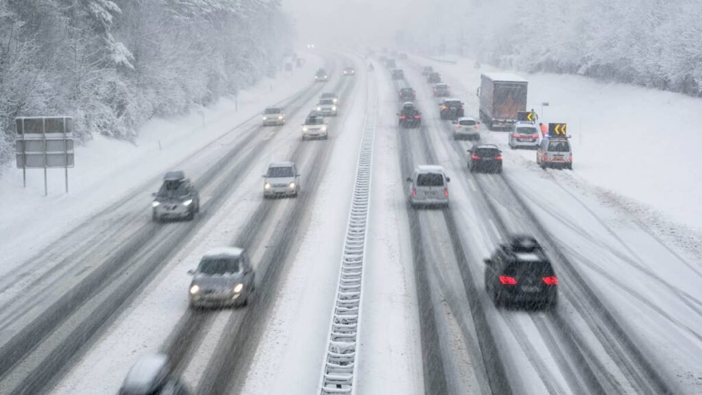
Less than three days after Wyoming’s late-season blizzard closed 200 miles of Interstate 80, the National Weather Service is signaling another round of mountain snow for the northern Rockies. The latest probabilistic outlook from the Weather Prediction Center shows the highest probability of heavy snow over the Absaroka Range, Beartooth Mountains, and Bighorn Mountains between Thursday evening, May 21, and Friday morning, May 22.
The signal strengthens through the 36-hour window. By 6 p.m. MDT Thursday, WPC modeling shows a 50 to 60 percent probability of 4 or more inches of snow across the highest terrain of NW Wyoming and S Montana, with cells centered over the Absaroka-Beartooth Wilderness and the Bighorn crest. By 6 a.m. MDT Friday, the cells split and weaken slightly, with the Bighorn cell maintaining the higher odds.
What’s Already Happening
The atmosphere is already showing its hand. Overnight Tuesday into Wednesday, fresh snow returned to I-80 east of Laramie and to US 287 between the Colorado state line and Laramie, less than 36 hours after Monday’s blizzard cleared. WYDOT rated the I-80 segment between Happy Jack Road and Buford as high impact early Wednesday morning, citing “Wet with Snowfall, Fog, Limited Visibility.” All three US 287 divided-highway segments through Tie Siding shared the same rating. This is a preview of the pattern that will reload Thursday into Friday over higher terrain to the north.
What’s at Risk
This is not an I-80 story. The trough is targeting mountain ranges 200 miles north of Monday’s blizzard zone, and the highway exposure is different. Three corridors are in the firing line:
US 14 and US 14A across the Bighorn Mountains. Granite Pass on US 14 and the steep grades on US 14A through Burgess Junction sit above 9,000 feet and cross directly into the WPC high-probability zone. NWS Riverton has already warned that travel through Burgess Junction could become “nearly impossible,” and the broader Wyoming-Montana-Idaho forecast calls for up to 24 inches of snow and 50 mph winds.
US 16 over Powder River Pass. The southern Bighorn crossing between Buffalo and Ten Sleep runs through the probability zone. This is a key freight and tourist artery into the Bighorn Basin.
US 212 Beartooth Highway. The route between Red Lodge, Montana and the northeast entrance of Yellowstone is the highest paved road in the northern Rockies at 10,947 feet. The pass typically opens for the summer season around Memorial Day, and a heavy late-season storm can delay that opening.
I-90 across southern Montana sits on the northern edge of the probability cone but is well below the high-impact terrain. Drivers between Billings and Sheridan should expect wet pavement and possibly snow at higher exits, but interstate-level closures are not signaled by the current outlook.
Why Late-May Snow Storms Catch Drivers Off Guard
NWS Riverton meteorologist Adam Dziewaltowski has previously described late-spring snow events of this magnitude in the Bighorns and Absarokas as “above normal for this time of year,” with the main concern being “people being unprepared for the conditions out there.” That framing applies cleanly to this week. Memorial Day travel is ramping up, RVs and pickup trucks with summer tires are already on the highways, and pass elevations above 9,000 feet remain capable of producing winter-grade conditions through late May.

What Drivers Should Do
The timing matters. This storm lands less than 48 hours before Memorial Day weekend, the unofficial start of summer travel in the West, with Yellowstone-bound traffic via the Beartooth and Chief Joseph Scenic Byways already building.
If you are planning to cross the Bighorns or drive the Beartooth Thursday or Friday, check WYDOT’s Wyoroad and Montana DOT’s 511 before departing. Our guide on best practices for driving in snow, ice, and rain covers the fundamentals. Cell coverage above 8,000 feet is very limited, and a stranded vehicle in a late-May storm at that altitude is the same survival problem as a stranded vehicle in February.
NWS Riverton and NWS Billings have not yet issued formal Winter Storm Warnings or Watches for the Thursday-Friday event. Based on WPC timing, the upgrade window is likely Wednesday into Thursday morning.
We will update this story as the alerts post.