Snow gets the headlines every winter. This year, ice did the killing.
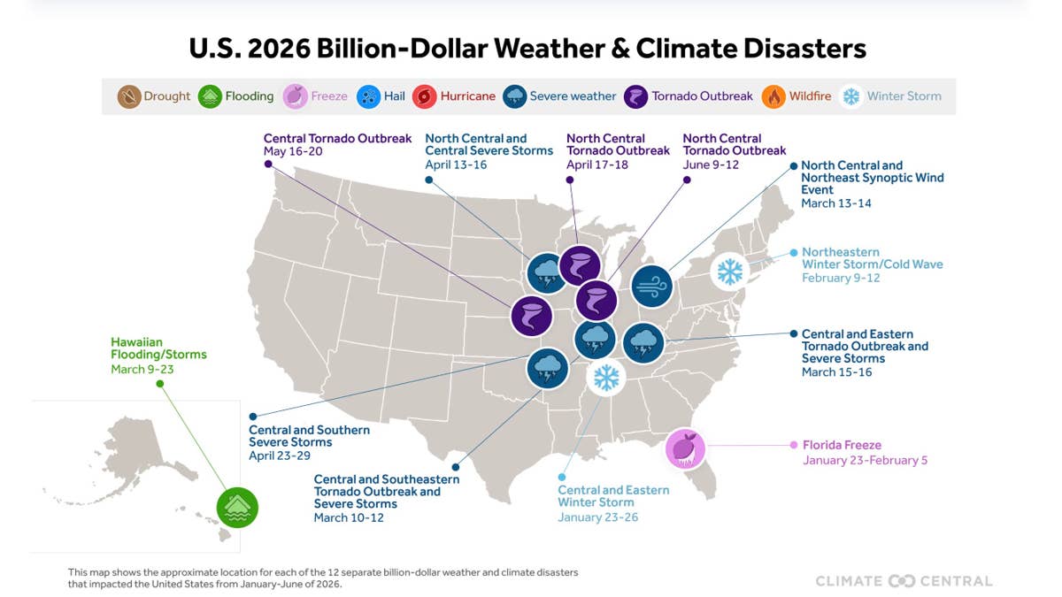
The map of 2026’s billion-dollar weather disasters makes the case better than any argument can. Twelve events, twelve icons, and the one that killed the most people is a snowflake sitting over the mid-South in January.
What Happened in January?
Climate Central
The Central and Eastern Winter Storm ran from January 23 to 26, pushing ice and snow northeast out of Texas all the way to New England.
Around Dallas it dropped an inch to an inch and a half of sleet. Around Austin the ice accumulation came to roughly a tenth of an inch. In the 22 hours from Sunday morning to Monday morning, the city reported that Austin police took 967 calls for service, among them 69 crashes and 91 traffic hazards, while EMS logged dozens more collisions and cold-related calls. A major wreck shut down Interstate 10 in Kimble County. About 2,400 flights were canceled at the Dallas, Houston and Austin hubs.
A tenth of an inch is about two and a half millimeters.
By the time Climate Central closed the books, that single storm accounted for 171 of the 183 people killed by billion-dollar weather disasters in the US in the first half of the year. The other 11 disasters killed 12 people between them, and that includes eight spring tornado outbreaks and severe storm events that ran up $22.1 billion, roughly three times the winter storm’s damage.
Which is the whole point. Ice was not the expensive hazard this year. It was the lethal one.
What Does Next Winter Look Like?
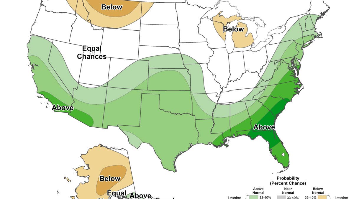
NOAA’s seasonal precipitation outlook for December through February 2026-27, issued Aug. 20, 2026.
NOAA/Climate Prediction Center
Aimed at the South, and that is where the ice risk sits.
NOAA’s Climate Prediction Center puts the odds of a very strong El Niño above 90 percent for this fall and winter. The pattern steers storms along a southern track with Gulf moisture behind them, and the National Weather Service office in Tallahassee describes the resulting Gulf Coast winter as cooler and wetter than normal, driven by that storm track rather than by Arctic air pushing down from the north.
As CNN put it last week, that combination across the Southeast and southern Plains is what sets the table for sleet and freezing rain, and how bad it gets comes down to how cold it actually turns.
For the rest of the country the picture is different, and Autoblog has covered it in detail. NOAA’s December through February outlook, issued August 20, pairs above-normal precipitation with a temperature forecast that does not lean warm across the Southwest, southern Colorado and coastal California. A separate OpenSnow forecast favors much the same group and leans thin across Washington, northern Montana and the Upper Midwest.
Those are snow forecasts. The southern tier is where the freezing rain risk sits, and it draws far less attention.
That last part is the catch. Across much of the southern tier the same wet forecast runs into a temperature outlook that leans warm, which is why a lot of that precipitation will simply arrive as rain. The dangerous zone is the narrow band in between, where temperatures sit close to freezing and a small shift in storm track decides whether the road gets wet or gets glazed.
One thing the forecast does not explain is last January. That storm was not an El Niño event at all. The Pacific was still in La Niña conditions through the winter, and El Niño did not develop until spring. Thin ice does not need a favorable pattern to shut down an interstate.
NOAA’s official winter outlook is due in mid to late October.
How Do You Protect Yourself on Ice?
Start by lowering your expectations of the car.
Winter tires help, and the reason is chemistry rather than tread pattern. Their compound stays pliable below about 45 degrees while all-season rubber stiffens and loses grip. On cold pavement and packed snow that difference is real. On glare ice the gap narrows sharply, and no tire restores normal braking distance on a surface with almost no friction.
All-wheel drive is the trap. It gets you moving confidently, which is exactly the problem, because it does nothing for stopping or steering, and that is where crashes happen. The car that pulls away from a light without slipping is the same car that cannot stop at the next one.
What is left is technique and timing.
Treat every bridge and overpass as ice. They lose heat from both sides and freeze before the road leading onto them, even when that road looks completely clear.
Double your following distance, then add more. You will not know the surface is bad until you brake, and by then the information is useless.
Brake before the curve, not in it. Any input while the car is loaded sideways is the input that breaks traction.
Watch for the overnight refreeze. Meltwater on warm afternoon pavement becomes a sheet after midnight. A road that looked merely wet at 8 p.m. is the classic setup.
Keep the tank above a quarter. A closed interstate can turn into a multi-hour wait, and the engine is your heat.
Pack for being stuck rather than for being cold. Blanket, water, phone battery, food, and a scraper you can reach without getting out.
And when the state asks drivers to stay off the road during an ice event, that request is doing more for your odds than anything bolted to the car.